Driving on the Edge
This page may appear a mess. The problem is that the original material was a series of emails sent from the road which were then collected into a travelogue in 43 separate linked files. This site rewrite will require all of this be be torn apart and reassembled into a single chunk. Also, note that the images were shot with a "state-of-the-art" digital camera circa 1997 and were edited down to be included in emails sent via a dial-up modem over sometimes-questionable phone lines. This is quite a long slog, far longer than a single web page should ever be, but you can click on the arrows ↑ ↓ to jump forward and back.Day 1, October 11, 1997: Anchorage to Tok, AK
↑ ↓ Psychologists rate moving as one of the more stressful events in most lives. If so, my move was par for the course. The moving crew showed up before I was ready for them on Friday, took items for shipping that should have been left, left items that should have been shipped and disappeared as quickly as they arrived. As a result I no longer had my blazer, slacks, and tie for the trip. I still had a dishwasher full of dishes. A trip to the post office at 6AM on Saturday will take care of the latter. The former will have to take care of itself.
This morning I awoke at 4:30 after a restless night on the sole remaining item of furniture in the house—the ratty old couch in the basement. My neighbors wanted it but relented and let me sleep on it for that last night. Breakfast was catch-as-catch-can from the nearly empty refrigerator. Leftover cherry cheesecake from my going-away dinner the night before wasn't too bad at 5:00AM. I packed my Miata with all of the clothes that the movers had spared, discovering once again that traveling light is a necessity in a car this small. Eventually everything was stuffed into place but the car now looked as though it belonged to Okies fleeing the dustbowl. I briefly considered strapping some furniture to the roof to complete the effect but realized that I had no furniture left after hauling the couch across the street.
On the way out of town I stopped in Eagle River to say goodbye to a good friend that had just returned from vacation the day before. Before I left, she managed to force a bag of food on me for the trip. Just what I needed there: more stuff to find a place for but she meant well and seemed really sad to see me going.
Hit the road at last at 8:30 after a tearful farewell. The weather is brutally cold for this time of year and the wind is whipping. The weather report shows that there has been snow down the Alaska Highway and makes it certain that if I don't get out now then driving will surely be impossible in a week (at least in a Miata with a hands breadth of ground clearance and twitchy handling in bad traction). A look at the Matanuska River as I head north shows that there is slushy ice floating by and confirms by astute observation
The road is in good shape for the first hundred miles or so. It slowly degrades becoming rather questionable in spots. There
are gravel stretches and construction zones - one of them 9 miles long. Some sections suffer from frost heaves. For those of
you unfamiliar with the treat, they are the result of freezing water beneath the pavement. At best they add a bit of rolling
motion and thumping. At worst they resemble an amusement park thrill ride in which patrons launch their vehicles into zero-gee
arcs and land with bone-crunching violence. I also observed an entirely new form of pavement misbehavior 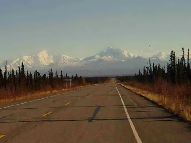 today in which the left and right sides of the road agree to a parting of
the ways leaving a meandering fissure down the travel lane. In some cases road crews had performed a half-hearted patching but
it seldom helped as the two sides invariably chose to travel at a different height.
today in which the left and right sides of the road agree to a parting of
the ways leaving a meandering fissure down the travel lane. In some cases road crews had performed a half-hearted patching but
it seldom helped as the two sides invariably chose to travel at a different height.
Eventually a mountain crossing had to be made. There was light fresh snow on stretches of road that were shaded. Other areas that had been warmed by the sun were either wet or icy. Amazingly the Miata handled it well enough giving me a bit more confidence in its winter handling (at least when abrupt changes of speed and direction can be avoided).
Arrived in Tok at 4:30PM not too much the worse for wear beyond some icing around the wheel wells. I enjoyed a light supper at a picturesque establishment called "Fast Eddie's". Not that bad despite the name and their beer was fresh...
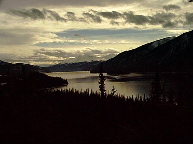
The attached picture shows a stretch of road with the mountains of the Wrangell-St. Elias group in the distance.
Tomorrow we press on to Whitehorse in the Yukon Territory as the next leg of our 12,000 mile solo tour driving on the edge of the US continues.
Day 2, October 12, 1997: Tok to Whitehorse, Yukon Territory
↑ ↓ Yesterday I wrote that "The weather is brutally cold for this time of year...". Well, after the weather in Tok this morning, yesterday seems balmy in comparison. Woke up to -3 degrees F and a thoroughly frosted up car. For our metric readers, this temperature is equivalent to several kilometers beyond bloody-well-freezing. The car defrosted in ten minutes, my fingers in twenty, but the road wasn't so cooperative.
The road stayed intermittently-to-solidly icy for a couple of hundred miles from Tok to past Kluane Lake. Fortunately the instincts for rear-wheel driving in icy conditions came back to me pretty quickly. I only embarrassed myself only once with a 180 spin and that was only while exiting a roadside pull-off so it might not count against my record. With luck I may be past the really nasty stuff now, although the Canadian weather service calls for snow here in Whitehorse tomorrow...
The scenery today was spectacular fading into boring. The early stretches featured beautiful snow-covered mountains and
spectacular lighting. To capture these adequately would call for a reincarnated Ansel Adams and was beyond me. Later on I was
presented with 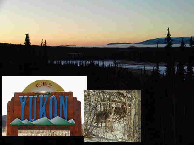 lower mountains and huge stretches of snaggy spruce
forests. Unfortunately the road was so bad in the early going that I couldn't spare attention for gawking.
lower mountains and huge stretches of snaggy spruce
forests. Unfortunately the road was so bad in the early going that I couldn't spare attention for gawking.
The roads, despite their icy covering, were pretty good in the Yukon. Far, far better than what I experienced back in 1976 when I last drove the whole route. Back then it was mostly gravel which turned to mud at the slightest provocation. This time virtually the entire stretch has been pavement of sorts although there is still some loose gravel floating around due to patching and a bit of construction. Overall the experience is vastly easier than it was.
Whitehorse has grown into quite a little metropolis since my last visit. Back then it featured a dozen bars and an A&W drive-in for entertainment. Now there are still a bunch of bars, although nicer ones, and there is still the A&W, but there are also some nice restaurants and theaters. The output from the local micro-brewery is quite palatable also. Whitehorse even has a well-equipped industrial area and the economy seems to be much improved.
The attached picture shows sunrise taken fifty miles outside Tok. Great scene, but difficult to capture well. The smaller insert shows one of only two wild mammals I've spotted. Had expected a lot of critters but there was only a skunk and this shy gray fox (or is that a coyote? I couldn't tell myself). The skunk was seen standing passively by the road seemingly waiting for the bus to come along.
Tomorrow we press on to Watson Lake at the Yukon Territory / British Columbia border as the next leg of our 12,000 mile solo tour driving on the edge of the US continues.
Day 3, October 13, 1997: Whitehorse to Watson Lake, Yukon Territory
↑ ↓ I awoke a bit later than normal this morning,
possibly due to the timezone change. That didn't matter since the leg of the journey planned for today was rather short. I
was greeted by an ominous leaden sky when I left the hotel. If there was ever a sky that looked as if it intended to do
something, this was it. I decided to press on since nothing untoward was actually happening yet. After a bit of bother getting
the GPS receiver working (it may not appreciate being left out in the cold car overnight) I got on my way at about 9:45. The
actual drive out of Whitehorse proved to be quite nice. The sky just continued to glower and did nothing. The highway was good
and then got better. On the best sections, the speed limit was up to 100kph (a bit over 60mph) and the road had actual painted
lines and wide paved shoulders. It occurred to me that with the road being so improved and easily crossed in virtually any
vehicle, that Alaska will be seeing a lot more bozos showing up. Then it occurred to me that this had probably already happened
and they just blended in with the resident bozos. As I passed over the continental divide, the headwind got rather strong and
made itself known by occasionally "popping" the convertible top on the Miata but caused no actual trouble. Later on a bit of
blowing snow started; that eventually turned into light powder snow but not enough to cause any problems. The snow eventually
did get a bit heavier about the time I pulled into Watson Lake and that motivated me to find a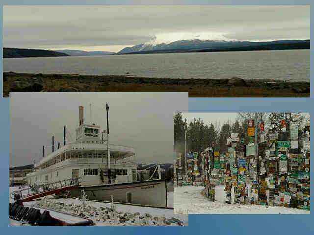 hotel with decent cable service, just in case I stay here for another
night. Right now it is a bit iffy whether I drive tomorrow or lay about. (a note to my mother, who reads these messages too and
worries incessantly about me: "Mom, I'm not taking any chances and am not doing anything at all dangerous. Believe me.")
hotel with decent cable service, just in case I stay here for another
night. Right now it is a bit iffy whether I drive tomorrow or lay about. (a note to my mother, who reads these messages too and
worries incessantly about me: "Mom, I'm not taking any chances and am not doing anything at all dangerous. Believe me.")
This is Thanksgiving Day here in Canada and I just had a "traditional" dinner at the restaurant. It looked suspiciously like a "traditional" Thanksgiving dinner in the US to me but I didn't tell them so. By the way, the cook has not a clue about making a pumpkin pie. Either that or Canadians are masochists about baked goods...
Today's picture shows a scene at Tetlin Lake. To me, the mountains in the distance looked as though they were in a losing battle to hold the clouds up. The first insert shows the steam paddlewheel boat "Discovery" in Whitehorse that used to serve the Yukon traffic. The other shows the signpost forest here in Watson Lake. It has long been a tradition for visitors to bring along a sign from their hometown or that they picked up on their journey and to hang it up in Watson Lake. Now there are many thousands of signs from all over the world. If you are missing a sign, it just may be here!
Tomorrow I may press on to Fort St. John, British Columbia if the road and weather look OK. Otherwise it is a good book and cable TV for me... And maybe the next leg of our 12,000 mile solo tour driving on the edge of the US continues.
Day 4, October 14, 1997: Snowed in at Watson Lake, Yukon Territory
↑ ↓ Who was it that talked about "deja vu all over again"? Well, that is what I'm feeling now.
I got up early this morning and checked out the weather ahead via the Environment Canada web site, looked around outside, and decided to give it a try. Got the car packed up, got my Nissan mug filled up with high-octane coffee at the truck stop, topped up the tank, and set out toward Fort Nelson.
The going didn't seem all that bad at first. I heeded the advice about winter driving given by the old-time automotive writer Tom McCahill to "drive like there are raw eggs taped to your pedals" and finessed the steering and managed to motivate 30 miles out of Watson Lake. My progress came to an end at the long steep grade that follows the Hyland River bridge. I made it 90% of the way up before I lost traction. Managed to do a sloppy 3-point turn and drive back down and try it again. Results were the same the second time so I bowed to the inevitable and came back to the motel room I had left earlier.
The people at the RCMP (Royal Canadian Mounted Police) post said that by tomorrow morning the road conditions would be vastly improved by plowing and sanding and warming temperatures. The Mountie who was telling me this certainly didn't fit the Dudley Doright mold of Mountie-dom, being pale, weak-chinned, and of expansive girth. Guess that too many years riding a desk rather than the traditional horse or dogsled has an effect on an officer.
 As an aside on the subject of trip preparation, I heartily recommend
that anybody considering this sort of drive give some extra thought as to the recorded music they carry along. The fact that
radio stations are few and far between up here means that you are on your own for entertainment. Due to my problems with the
movers grabbing things and packing them I was left with a sorely limited collection of cassettes: 2 anthologies of dowop
classics, 1 Platters anthology, 1 recording of Hawaiian music by a performer who's name I can't recall, 1 collection of
J.S. Bach harpsichord and clavichord music, and a tape of the Celtic group "Silly Wizard".
As an aside on the subject of trip preparation, I heartily recommend
that anybody considering this sort of drive give some extra thought as to the recorded music they carry along. The fact that
radio stations are few and far between up here means that you are on your own for entertainment. Due to my problems with the
movers grabbing things and packing them I was left with a sorely limited collection of cassettes: 2 anthologies of dowop
classics, 1 Platters anthology, 1 recording of Hawaiian music by a performer who's name I can't recall, 1 collection of
J.S. Bach harpsichord and clavichord music, and a tape of the Celtic group "Silly Wizard".
The Hawaiian recording seemed an especially cruel thing this morning since, as the singer was extolling the virtues of "white sand beaches" I was sliding around on something far more white and not nearly so pleasant. I discovered early on in the trip that listening to Andy Stewart of Silly Wizard too closely as he sings beautiful maudlin songs in Scots dialect while I am surrounded by majestic scenery is enough to choke me up a bit.
I guess that I'll do some reading while I'm here as I did bring along a half-dozen novels. Perhaps I should continue reading "Independent People" by Halldor Laxness. A bleak book by a depressed Icelandic author seems appropriate somehow...
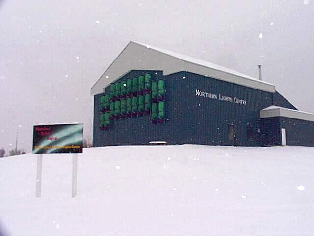
Not much in the way of photography today. The attached image shows something called the Northern Lights Center and I have not a single clue to what it might be. It is clearly set up for tourists with lots of parking, etc but beyond that it is a mystery.
Tomorrow I may press on to Fort Nelson, British Columbia if the road and weather look OK. Otherwise it may be time to start looking for a house for the winter (just kidding, Mom!). And maybe the next leg of our 12,000 mile solo tour driving on the edge of the US continues.
Day 5, October 15, 1997: Watson Lake to Fort Nelson, BC
↑ ↓ And a heavy sigh of relief was heard...
I finally made it out of Watson Lake and into Fort Nelson. It wasn't an easy day but things should improve rapidly tomorrow as I head due south and out of the frozen lands.
This morning I was not really certain about leaving. It didn't snow overnight but there was freezing rain that left the Miata heavily encrusted. A look at the Environment Canada weather web site didn't help a bit as the needed information was "Not Available". The radio station had warnings about the freezing rain but truckers coming north said it was pretty decent. The RCMP said that the road crews had been out over the whole stretch of highway but the rain might have undone some of their work. What to do, what to do? Oh the hell with it, let's give it a shot!
 So,
armed with another Nissan mug full of trucker juice, I set out. Well, the road didn't look all that good but it must have
been much better - the hill that stopped me the day before fell behind me and my confidence came back a little. Not enough to
make me push as fast as some of the other vehicles were going, but I did push on. Perhaps I was still intimidated by the events
of day 4. Thoughts of it certainly did keep my concentration focused tightly on the road. No music today. Two hands on the wheel.
Speed under 40mph. I am usually a relaxed driver but there was real tension in the car today.
So,
armed with another Nissan mug full of trucker juice, I set out. Well, the road didn't look all that good but it must have
been much better - the hill that stopped me the day before fell behind me and my confidence came back a little. Not enough to
make me push as fast as some of the other vehicles were going, but I did push on. Perhaps I was still intimidated by the events
of day 4. Thoughts of it certainly did keep my concentration focused tightly on the road. No music today. Two hands on the wheel.
Speed under 40mph. I am usually a relaxed driver but there was real tension in the car today.
The road varied from continuously to intermittently nasty for the first 250 miles. But true to their word, the road crews had been out over night and scraped and sanded the worst sections. Other than a few minor twitches, the Miata handled the road well (at least while being driven slowly and with single-minded concentration). This should be a lesson for anybody else trying this sort of drive in uncertain weather: get yourself some cable chains for your Miata before you begin. Regular chains won't fit it and cable chains just aren't available in out-of-the-way places.
There were some nasty winds in the Liard Hotsprings area. I can't really give a number for it but it must have been gusting 40mph. But is was gusting primarily from the south and the road was thawing a bit. By the time I got down to Muncho Lake there were extended slushy / wet stretches. This in itself was a problem for the Miata. Those fancy splash guards I had added to the vehicle were also excellent slush scoops. Combined with the tight clearance around the wheels, the car came down with a serious case of "wheel boogers" (to coin a tasteless phrase). In fact, the spacing was so tight and the slush so impacted, it was nearly impossible to remove and I just had to live with it and hope for the best.
There was some wildlife to be seen today. I was paying so much attention to the road at the beginning that almost anything might have escaped my attention - I wouldn't have seen 8 yeti playing volleyball beside the road! However, later on, when I relaxed just a little I did spot an immature bald eagle (not a big deal to me since they used to live and nest in Anchorage, but some might think it unusual). Also saw a loon but it acted as though it might be sick or crippled and I suspect that any loon hanging around this late in the year is soon to be a late loon.
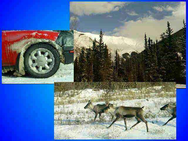
Down near Muncho Lake, I really hit the jackpot. Actually, if I hadn't been so careful I would have literally hit the jackpot. There were numerous caribou around the lake, totally fearless, and in no great hurry to get off the road. The ones in the picture blocked the road in both directions until a motor home in the opposite lane tried to edge through.
To make up for that grim image I sent yesterday (reflective of the weather and my mood, no doubt) there are two images today. The first is a full frame of Muncho Lake taken from a rise to the north-west. The other is a montage of caribou, the first blue sky seen all day, and a bad case of "wheel boogers".
Today was overly long and tiring but tomorrow I head due south and plan to stop at Dawson Creek, BC. Next stop after that will probably be in the US of A on the next leg of our 12,000 mile solo tour driving on the edge of the US.
Day 6, October 15, 1997: Fort Nelson to Dawson Creek, BC
↑ ↓ This will be a short one. The roads were good, the scenery was nil, and nothing much happened...
There was a fairly heavy fog in Fort Nelson when I left and it stayed with me for a few hours until the terrain got high enough that it became a cloud below me. This was a cold fog, precipitating out little ice crystals that blew around the highway in response to passing vehicles. The fog was dense enough that driving was as if in a cotton wool tunnel. Visibility was good enough down the road to maintain good speed but the scenery, if there was any, was blurred into nothing.
As it turned out, most of the drive was along what seemed like a series of high N-S plateaus divided occasionally by river canyons. The northern part of the drive was clearly through a logging area - all the signs were there, including logging trucks hurtling out of the murk toward me. The central part of the drive shaded into what was clearly an energy production area, apparently natural gas is a big thing in this region. There were also a surprising number of agricultural features toward the south with hay production giving way to wheat. I can verify the latter because of the number of wheat elevators in the area.
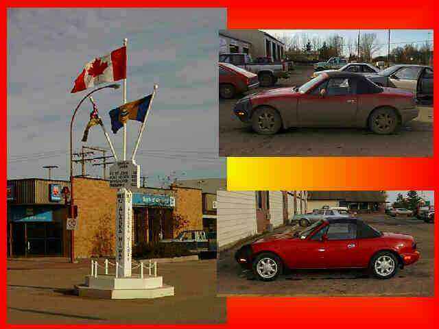 Dawson Creek is a bigger
town than it was the last time I went through it 20+ years ago. One constant is the marker in the middle of town marking mile 0
of the Alaska Highway. This often-photographed marker has been through a few reincarnations in its 50-year history but has
remained a popular feature to be photographed with. By the time I arrived here, the temperature was an absolutely balmy
12-degrees C. - pretty much tee shirt weather for an old (former) Alaskan. This was a major relief after the past few days.
Dawson Creek is a bigger
town than it was the last time I went through it 20+ years ago. One constant is the marker in the middle of town marking mile 0
of the Alaska Highway. This often-photographed marker has been through a few reincarnations in its 50-year history but has
remained a popular feature to be photographed with. By the time I arrived here, the temperature was an absolutely balmy
12-degrees C. - pretty much tee shirt weather for an old (former) Alaskan. This was a major relief after the past few days.
The only other exciting thing in my day was the ritual washing of the Alaska Highway from the car. If you added up all the dirt the Miata has had on it in its entire life, it couldn't match the load it went into the car wash with this afternoon. A "tooie" and a "loonie" ($2 and $1 Canadian coin) later in the machine and she looked fairly presentable.
Image for today is the aforementioned marker and before and after pictures of the car. Hey, they can't all be winners and I warned you that this was a dull day.
My original plans for tomorrow were to push on to Riverside, Washington but after looking at the distance involved, I have decided to find a mid-way point and stop there. Don't know where it might be, but I'll try for something a bit more interesting to report on tomorrow (now, finding something more interesting than today shouldn't be to difficult, should it? ).
Tomorrow we press on to somewhere in southern BC and continue the next leg of our 12,000 mile solo tour driving on the edge of the US.
Day 7, October 17, 1997: Dawson Creek to Quesnel, BC
↑ ↓ I finally decided on this town as a destination for no other reason that I had never heard of it before. It turned out to be a pretty good blind choice since it is rather attractive and I wound up with a dynamite motel room I can highly recommend the Talisman Inn in the unlikely event that any of you happen through this town.!
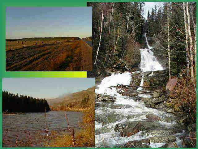
Starting out in Dawson Creek this morning was quite pleasant. Temperature had dipped to freezing overnight and there was a little frost on the car but it was bright and clear. I drove through a largely agricultural high-prairie area. Not the most exciting scenery imaginable, but I did snap one picture for the record. Hard to decide whether grazing cattle or rolls of hay is the more stimulating picture.
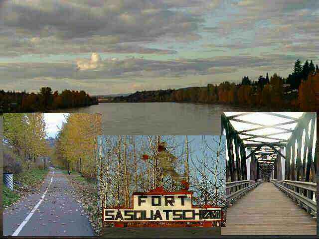 Later on I got off of the prarie and into some more mountainous country and some interesting river scenes. Stumbled across a sign
for "Fort Sasquatch" and had to investigate further. Turns out that it is a B&B virtually hung over the East Pine river.
Looks like it could be an interesting place to stay during warmer weather.
Later on I got off of the prarie and into some more mountainous country and some interesting river scenes. Stumbled across a sign
for "Fort Sasquatch" and had to investigate further. Turns out that it is a B&B virtually hung over the East Pine river.
Looks like it could be an interesting place to stay during warmer weather.
Drove through Chetwynd, BC which is the "Logging Capital of Canada". If you don't believe their claim, they have large signs on the road into and out of town to tell you so. Actually, for a logging town, it looks quite appealing. Housing is modern and they seem to have enough stores and entertainment to make it liveable.
Heading up into the mountains a bit later on I came across tall gates like those at a railroad crossing. Only thing is that there was no track. Finally it came to me where I had seen things like this before: in the high Sierras in California. They were snow gates which are closed when the local authorities determine that trying to clear the roads is a losing proposition. In the Sierras they block off 10,000-foot passes and the ones here were blocking a much lower area but perhaps they get worse snow here (or have a lower tolerance).
Saw my first real waterfalls on this drive. Something called Bijoux Falls. Quite pretty but getting close enough to photograph it was a pain. The spray was freezing cold and the rocks were slippery so I didn't try for anything fancy. Also noticed that the place in the parking lot where the Miata was parked showed signs of recent water flow (wet leaves and twigs in trails) and decided that the recent "El Nino" rainfalls that hit the BC coast yesterday must have gotten over the mountains a bit.
Went through Prince George but wish I hadn't. The best thing about it was the leaving. This is one of those places that "jest growed" and is all the worse for it. Ugly, foul smelling, and noisy pretty well describes how it impressed me. Guess you could say that Prince George is like a blister on the earth raised by the friction of commerce.
I got into Quesnel in time to eat and take a strenuous walk. There is a nice riverside park here along the Fraser River. About 1km down the trail from the motel there is a footbridge across the river although I only went about half-way across.
Pictures today include the falls , an agricultural scene and the view from Fort Sasquatch. The other shows the view from half-way across the footbridge, the trail in the park, and the bridge itself.
Commentary: drivers up here are an interesting bunch. They don't give a damn about speed limits for example but seem oddly polite about it. Up in Anchorage, drivers are constantly in "digital communication" (signals made by the raising of a single digit, readily convertible to the two-digit English encoding). Up here they have been tailgating me constantly as I cruise along exactly at the speed limit and occasionally do some foolish things to pass me, but not one has given me the universal greeting in passing. Strange...
One last item. I drove into something really wonderful today: autumn. Down here in Quesnel, there are still leaves on the trees and plenty of flaming foliage. It certainly isn't Vermont and the primary color is yellow but it is a vast improvement over anything I've seen in a while.
Tomorrow we will definitely press on into the US of A and possibly do our first visiting of the trip as we continue the next leg of our 12,000 mile solo tour driving on the edge of the US.
Day 8, October 18, 1997: Quesnel, BC to Omak, Washington, USA
↑ ↓ If yesterday was the day I drove into Autumn, then today is the day I drove into a couple of more seasons. Weather and conditions ranged into winter as I crossed a range of mountains and into a virtual late summer as I headed through the valley surrounding Okanagan Lake .
 Early this morning I started out in a fog - literally and
figuratively. For some reason my mind wasn't functioning well at all. The early part of the day was spent in largely
agricultural and logging areas. Later on I descended into a surprisingly desert-ish area - sagebrush and all. Then it was up into
a mountain range complete with snow and pine forests. Then it was down into the area of Okanagan.
Early this morning I started out in a fog - literally and
figuratively. For some reason my mind wasn't functioning well at all. The early part of the day was spent in largely
agricultural and logging areas. Later on I descended into a surprisingly desert-ish area - sagebrush and all. Then it was up into
a mountain range complete with snow and pine forests. Then it was down into the area of Okanagan.
The valley that surrounds this long lake is home to many orchards and vineyard as well as vegetable farms. It seems that at least every mile along the highway there is a roadside fruit stand of some sort. Sometimes they are cheek-to-jowl for long stretches. Wineries abound in this area but unfortunately all of the tours seemed to be closed for the season. Or maybe I should say fortunately since I was quite late in ending up today's drive. Seems that my estimating talents aren't improving.
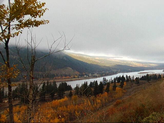
I'll cut short tonight as I am tired and you are all probably tired of reading. One picture today: a view of the Fraser River valley in the fog this morning.
Tomorrow I will probably be staying in this area to do some visiting with a friend, Karen Sanders, who used to work with me at the Alaska Court System. She had the sense to take an early retirement a couple of years ago and moved to this area with her husband, Denny, where they own an old farm out in the boonies just north of here. Just finding their house might be a challenge.
On Monday or Tuesday we will continue the next leg of our 12,000 mile solo tour driving on the edge of the US.
Day 9, October 19, 1997: Hanging around in north-central Washington
↑ ↓ I got into Omak, Washington last night a bit late and
let my friend Karen know that I was here. Unfortunately, she had already committed to helping somebody get a computer working and
so I was unable to spend the day with her. She came to the motel for a quick chat in the morning and then said that she would
meet me 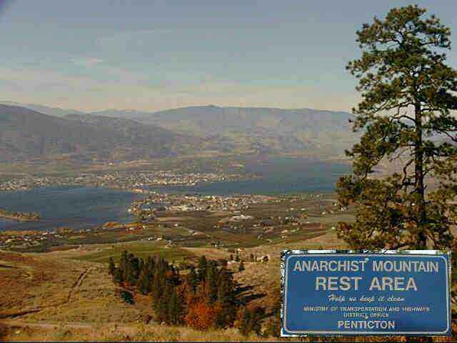
 in the late afternoon in front of the general store in Riverside and lead me to her house. That left me with a day to
kill.
in the late afternoon in front of the general store in Riverside and lead me to her house. That left me with a day to
kill.
To see what I missed in southern Canada the afternoon before, I drove up into the fruit and wine area for a look around. I took the opportunity to buy some BC wine for dinner that night (an OK Pinot noir but nothing to make the folks in Napa sweat). Also drove up into the mountains to the east of Osoyoos for a look around. This must have been a major engineering feat back when it was done because the road is a series of severe switchbacks that seems to be trying to climb a vertical cliff. /p>
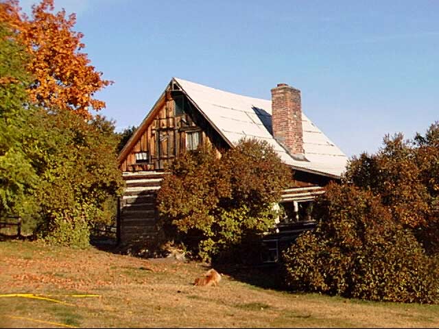
That evening when Karen led me to here house I didn't really know what to expect. From the map, it was obviously a fairly remote area. The road, narrow winding but paved, went for 15 miles from Riverside. Then we turned off onto a dirt road where the warning sign at the entry read "Primitive Road". This is local parlance for "hardly a road at all". It followed what must have been a wagon track for 3.5 miles up a fairly steep climb until we stopped at her house. The house itself is a cabin, modernized a bit over the years, built originally by homesteaders in 1898.
We had a nice visit and a very late dinner but my biggest surprise came a bit later. Living around "civilization" has spoiled many things for people but I discovered one that most never think about. Did you know that there are stars? No, not the few that you can see through the light pollution that seems to exist everywhere, but tens of thousands of them. The Milky Way is still there and the overall effect is truly dazzling. Last night I stood outside in absolute blackness for the first time in decades and stared at the sky even though I was in shirt sleeves and the temperature was down to freezing.
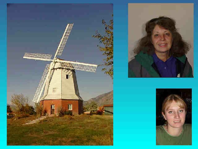
Pictures for today are: a view of the Canadian wine and fruit area from way up above and a sign seen at a rest stop (I figured that the anarchists were all in Washington and Idaho on the US side but they must have had some up north); a picture of a "tourist attraction" in Ossoyoos, BC (for sale and it might be just what you are looking for), my friend Karen Sanders, and our waitress for breakfast who didn't believe that she might show up on the Internet. (see, I told you so ).
I will probably be leaving here on Monday after we feed the chickens and ducks here and go tend the neighbor's livestock. Next stop is somewhere in the vicinity of Poulsbo as we continue on the next leg of our 12,000 mile solo tour driving on the edge of the US.
Day 10, October 20, 1997: Riverside, WA to Leavenworth, WA
↑ ↓ Not many miles today. Partly that is because of a late start. Partly it is because I took a computer's advice uncritically (will I never learn?).
I left Karen's and Denny's place a bit after noon. This morning I helped to feed and water her critters as well as those of a neighbor (up in this area, neighbor means somebody ½ mile down the mountain). Karen keeps three dogs, four cats, seventeen chickens, two ducks, and two horses. A few weeks earlier and there would have been a steer and a pig to take care of but they have recently take up residence in the freezer. There are also six sheep but they tend to wander away looking for greener pastures on the mountain and return when they feel like it. Then again, since there are numerous cougars in the area, they sometimes don't. Two years ago Denny said they lost seven sheep to a single cougar. Guess that the sheep are the natural version of Purina Puma Chow when the deer prove too difficult to catch on the mountain. The neighbor has even more chickens as well as chukars, pheasants, turkeys, and a sheep.
I packed up and went down the mountain and back to town. After the trip over so many miles of dusty road the car needed a wash so I did that. I then entered my desired route into the computer (shortest route between Riverside and Poulsbo), started up the GPS, and then followed the instructions the machine gave me to the letter. I finally got a little concerned as I found myself going up the Mad River Canyon and on to progressively more narrow and winding roads and eventually onto a gravel road that headed out into an area that looked essentially untraversable. THEN I checked what the computer was telling me to do. Oh well, I winged it after that and made my own way over the Cascades following more conventional routes. The computer was, it appears, giving me exactly what I asked for but not what I really wanted or needed.
My route put me into the town of Leavenworth, WA at about quitting time so I decided to stay here. Have you ever been any place that just makes you nauseous? That is the effect this town has on me. First off, as a ploy to attract tourists, the whole town (yes, even McDonalds and Burger King) is done up in a very phony Tyrolean theme. As tacky as this is, they have an attitude on top of it. The first, rather modest-looking motel I stopped at quoted a price of almost $100 a night. The second one was going to charge me $0.25 a minute to make 800-number calls. The third, where I finally decided to stay, had reasonable rates and free phones despite being old-fashioned and having the mandatory pseudo-Tyrolean decor. Oh well, you can't have everything.
It strikes me that a few towns on my route have these pseudo-ethnic themes. Besides this one, there is Poulsbo, WA with a Norwegian theme and Solvang, CA with a Danish theme. At least those two have the distinction of actually having populations largely of the claimed nationality. It strikes me that this town might be the actual explanation of those Nazi war criminals that didn't make it to South America. I can just see them landing in the mountains of Washington in 1945 and hatching their plot to prey upon tourists for generations to come.
Back to more pleasant stuff: last night at Karen's was an experience! The house is a log cabin originally built by homesteaders in 1898. There have been additions over the years (yes, telephone, electricity, and TV) but the ambiance is still very old. The house has settled at an odd angle over a century giving it a dynamic feel. The heat comes from a wood-fired cooking stove in the kitchen as well as a cast iron stove in the living room. I slept in the loft/upstairs that normally act as Karen's craft and sewing room. The bed was an iron beast left behind by the original builder and the mattress appeared to be an actual feather bed.
 I slept pretty well once I got into bed but with a few unexpected
interruptions. First it was cats. Two of them apparently were hiding upstairs. One jumped onto the bed immediately after I got in
and proceeded to groom herself noisily. I picked her up and put her down the stairs and closed the door. An hour later, a second
cat jumped into bed with me. This one turned out to be a virtually wild cat that hangs around and deigns to be fed with the
others. Karen said that the cat hides for days on end and is seldom seen. In the middle of the night I was awakened repeatedly by
barking dogs and yipping coyotes. The dogs make it their business to keep the coyotes away from the chicken coop but are not
quiet about it. Finally this morning I was awakened by the rooster outside and the approaching light of dawn (that and a
temperature around freezing in the bedroom. I was comfortable under a thick layer of blankets and a down comforter but was
totally unmotivated to get out of bed).
I slept pretty well once I got into bed but with a few unexpected
interruptions. First it was cats. Two of them apparently were hiding upstairs. One jumped onto the bed immediately after I got in
and proceeded to groom herself noisily. I picked her up and put her down the stairs and closed the door. An hour later, a second
cat jumped into bed with me. This one turned out to be a virtually wild cat that hangs around and deigns to be fed with the
others. Karen said that the cat hides for days on end and is seldom seen. In the middle of the night I was awakened repeatedly by
barking dogs and yipping coyotes. The dogs make it their business to keep the coyotes away from the chicken coop but are not
quiet about it. Finally this morning I was awakened by the rooster outside and the approaching light of dawn (that and a
temperature around freezing in the bedroom. I was comfortable under a thick layer of blankets and a down comforter but was
totally unmotivated to get out of bed).
Picture of the day is Karen's 1898 cabin in the mountains, slightly edited to remove the temporally jarring TV antenna.
Tomorrow morning I will press on through Poulsbo to make my pilgrimage to Sluys Poulsbo Bakery and then on toward the Olympic Peninsula. And we continue on the next leg of our 12,000 mile solo tour driving on the edge of the US.
Day 11, October 21, 1997: Leavenworth to Sequim, WA
↑ ↓ As I sit here writing this in Sequim (pronounced SQUIM, no matter how it is spelled) I will not be able to send it out until tomorrow night. Seems that this motel has a digital, not analog, phone system and will not work with my modem. Guess that I'll have to add another question to my pre-registration interrogation from now on: Do you have a non-smoking single available? How much does it cost?. Can I make free 800-number calls from the room? Is your phone system analog?
Didn't go terribly far again today. Not because of any problems but simply because I didn't feel like pushing. Had a rather late start this morning and took a couple of side trips along the way. Tomorrow will probably be a busy one since it is the first time actually "on the edge".
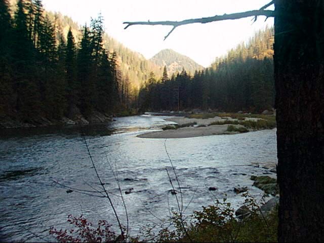
 Early on this morning I headed across the heart of the Cascade Range and came across some really spectacular scenery. One picture
today is a morning view of the Wenatchee River tumbling down from the east side of the mountains. This scene is also a genetic
test: if you can look at it and your casting arm does not give at least a perfunctory twitch, you do not possess the fishing
gene. I am not much of a fisherman but to me it just cries out "here there be trouts".
Early on this morning I headed across the heart of the Cascade Range and came across some really spectacular scenery. One picture
today is a morning view of the Wenatchee River tumbling down from the east side of the mountains. This scene is also a genetic
test: if you can look at it and your casting arm does not give at least a perfunctory twitch, you do not possess the fishing
gene. I am not much of a fisherman but to me it just cries out "here there be trouts".
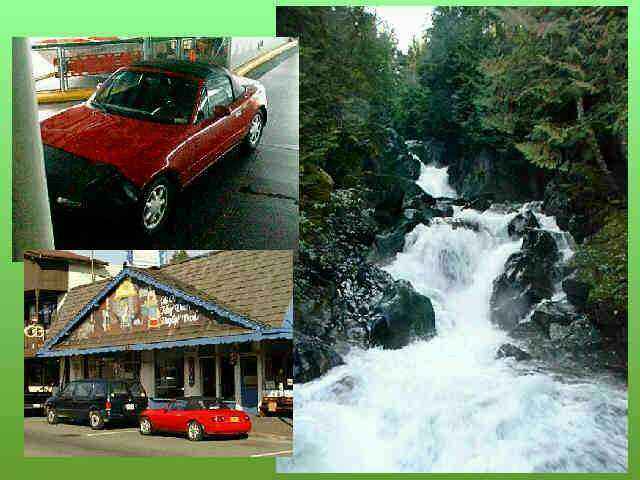
In the other picture is something called Deception Falls. Actually this is the upper falls and it continues falling for some time more below this. To get to the upper falls you have to traverse a walkway which leads to a catwalk suspended under a concrete highway overpass which bridges the torrent. The roaring echo from the falls inside this concrete box is really awesome. I wanted to do some walking down the stream where there are massive moss-covered fallen trees and huge rocks but I still get nervous about parking my car where I can't see it when the computer is sitting in the front seat (although I do my best to camouflage its presence.
The computer and GPS managed to get me through the maze of Seattle suburbs to the Edmonds ferry terminal pretty well, although the shortest route might not have been the best way again today. Luck was with me and the ferry was ready to start loading within minutes of my arrival. I haven't seen a lot of ferry systems, but I understand that many of them are really disasters. The Washington ferries have always impressed me as being really well run and efficient.
I set of on the M.V. Yakima which was about half-filled. The six-mile crossing to Kingston only takes about 20 minutes, just about long enough to go up to the coffee shop and pick up a sandwich (reasonably priced and of pretty good quality as opposed to some ferry fare I've experienced before).
After getting off the ferry, it was only a half-hour to my intended destination -Poulsbo , home of the Sluy's, the best little bakery in the west (IMHO, of course). I picked up my sweeties, princess bars which are a date-filled confection, stashed them in the cooler and did a quick walk-around downtown. As usual, there were quite a few tourists about and the town itself seems to have undergone some growth since my last visit but it isn't to the point of being unpleasant. Poulsbo IS one of those ethnocentric tourist traps that I lamented yesterday but aren't nearly so oppressive about it as Leavenworth. And, in their defense, they do have enough Norwegian-descended folks about to support a large Sons of Norway Lodge. In fact, some non-Scandinavians I've spoken to here in the past claim that they continue to feel that they are excluded from the real community's heart.
On the way west toward the Olympic Peninsula (and the edge) I noticed the turnoff to Port Townsend . I have been past here a few times and never bothered to take the detour. Today there were no excuses. Port Townsend proved to be a pleasant place (with the notable exception of the paper plant a few miles out of town - what a stink!) and seems popular with the tourists also. The town was built in Victorian times and still has a large number of historic structures. In fact, both the downtown and uptown districts are on the registry of historic places. On to Sequim...
Sequim is one of those growth disaster zones. It has exploded so quickly as to become unpleasant. What was once a wide spot on the road to Port Angeles is now a mass of traffic, stores, and houses with no sense of planning. I guess that the early land owners probably cleaned up on the growth and are happy with their money wherever they moved off to after they sold out...
Oh well, there will probably be plenty of solitude starting tomorrow morning after I really get onto the edge. Aside from a few long-established touristy areas down the Washington, Oregon, and Northern California coast there isn't much to support population growth and the areas are sufficiently remote and poor that there shouldn't be too much Sequim-ization going on down there.
I have already described one picture for the day. The other is a montage of Upper Deception Falls, the Miata on its first ferry ride, and the Miata parked in front of Sluys Poulsbo Bakery. I can't help it, even after all these years, I'm still infatuated with my little car .
Tomorrow morning I will actually hit my first corner and onto the edge as we continue on the next leg of our 12,000 mile solo tour driving on the edge of the US.
Day 12, October 22, 1997: Sequim to Pacific Beach, WA
↑ ↓ Well, who'da thunk it. I'm cut off from communications for a second night in a row. I could manage it fine from the wilds of the Yukon but can't manage in Washington.
I spent a long time today hiking and photographing earlier and when I headed south I got caught in some unexpected housing problems: in Forks all of the available rooms are tied up by a movie crew that is shooting in the Hoh Rainforest. I figured (wrongly, it turned out) that a short drive down the south would turn up a room. There was an absolutely beautiful lodge along the shore a couple of hours back but I turned my nose up at it because there were no phones in the rooms. So here I sit in Pacific Beach , also without a phone, but in much less attractive surroundings, and far more tired. Live and learn...
Since time wasn't a concern this AM, I spent a bit of extra time in Port Angeles having the oil changed in the car. It is hard for me to believe that I have put 3,000 miles on the car since the last time it was done a few days before leaving Anchorage. The poor car went for almost seven years and still didn't have 30,000 miles on it and now it is getting 3,000 in ten days.
This morning was foggy and misting a bit of rain. That seemed like ideal weather for traveling in the Olympic. On starting out, my plans included going out as far as Neah Bay. In fact I didn't know it was possible to go any further. Luckily it was and I was able to really get to the edge of America to make my start. Driving out toward Neah Bay took me through some wonderful areas. Some of them appeared to just be exploding with plant ife, showing every imaginable shade of green in every direction. It seemed that anything that wasn't able to get out of the way wound up covered in moss and ferns. Even the still-living trees has moss over every surface and ferns growing out of their trunks. Dead and dying trees had the added burden of epiphytic "Spanish" moss (calling it that out here doesn't seem quite proper, but I don't have another term for it).
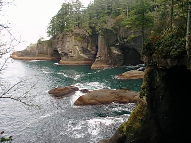
Upon getting to Neah Bay I discovered that roads of sorts went further out the peninsula toward Cape Flattery ("Nice cape you have there, Marge", "What? This old thing..."). A paved road went out as far as what used to be an old Air Force station until the 1970's but which is now part of the Makah Indian reservation. Beyond that the road was gravel/dirt and pretty nasty in places but still passable. Eventually the road ended at trailhead many miles from Neah Bay (the technical term for this distance is "waythehellandgone"). A 1 mile round-trip hike leads to the actual cape from the trailhead. The hike was not bad going out, being mostly downhill. Of course the way back was not as easy. Add to this the fog, mist , and 100% humidity and I was a pretty damp puppy but the walk was definitely worth the effort. The tribe owns the entire territory and has built paths and walkways where needed to pass through the heavy terrain. The views at the far end are, to say the least, impressive. The trail ends in several cliff overviews in different directions and reveals pounding surf and gigantic sea caves. I'd guess that anybody in reasonable health could make the walk although if you suffer from acrophobia you might want to look elsewhere.
 Later in the day I headed south looking for interesting sights
along the way. One outstanding place was Rialto Beach. It is somewhat out of the way but is worth the trip. I'd really like
to go there and watch the sunset (preferably with somebody warm and cuddly). The setting is perfect and offshore there are a
grouping of stack rocks, but unusual ones with trees growing on them.
Later in the day I headed south looking for interesting sights
along the way. One outstanding place was Rialto Beach. It is somewhat out of the way but is worth the trip. I'd really like
to go there and watch the sunset (preferably with somebody warm and cuddly). The setting is perfect and offshore there are a
grouping of stack rocks, but unusual ones with trees growing on them.
Because I didn't stay in Forks I continued on my pre-ordained route hoping to find a place to stay. As luck would have it, the route called me away from a likely lodging place and down a lonely road back toward the ocean. Part of my unwritten rules demand that I go toward the water when possible so down the road I went. As luck would have it, the road turned to gravel for ten miles as it wound through a reservation and went on endlessly. And that is the sad tale leading up to my present lodging and lack of communications.
Today's picture is a view from atop Cape Flattery's cliffs of sea caves big enough to hide a large ship in.
Tomorrow morning I will continue down the left edge as we continue on the next leg of our 12,000 mile solo tour driving on the edge of the US. And who knows? I may even find a motel room with a phone to send what I've been writing.
Day 13, October 23, 1997: Pacific Beach to Long Beach, WA
↑ ↓ Well, I managed to convince the manager at the motel
from last night to let me hook up to the office phone line to send out my stuff. From now on, I'll be a bit more selective
about my motel choices when a choice 
 presents itself. Last night would have been an exception under any
circumstances.
presents itself. Last night would have been an exception under any
circumstances.
Today was very short in mileage but not in touristing. Poked into lots of stuff however not much of it resulted in pictures. Today you will see a conglomeration of oddish stuff seen along the way presented without comment. The other is Rialto Beach, WA from yesterday.
Right now I'm in Long Beach , WA which seems to be the kite capitol of the country. They have several kite manufacturers here and several more stores. I looked around but decided that spending hundreds of $$$ on a kite would probably not be a smart move especially considering how the car is already packed. I tried flying my little frameless kite earlier today at a beach north of here but the wind was so incredibly strong that the little beast almost took my fingers off with the strings. Back into the sack and into the trunk it goes...
I did find a real bargain vacation spot for any of you who are eligible. At Pacific Beach, there is a facility belonging to the Navy which they call a "Conference Center" but which is actually a R&R center. Prices are great: you can get an entire house on the beach for $75 a day during the peak season and half of that during the off season. If you have ever looked at the prices for just a room on the beach you will appreciate the difference!
I thought I'd have a great picture for you but it didn't come out very well. In the museum / gift shop next door to this motel is the one, the only, the original alligator man, a very nicely-done sideshow gaff much renowned in the tabloids. Barnum would have liked this one.
I am staying tonight immediately north of the Oregon border and will surely get there tomorrow as we press on with our 12,000-mile tour of the edge of the USA. Maybe I'll find something more photogenic tomorrow.
Day 14, October 24, 1997: Long Beach, WA to Yachats, OR
↑ ↓ Another short distance day today. If my trend of fewer and fewer miles every day I'll be lucky to make it down the coast before I become totally immobile and have to stay permanently.
First thing this morning I drove up from Long Beach to Oysterville hoping for some interesting old Victorian houses. Turned out that the whole old village is of that era but the houses are hardly the sort I had hoped for. Seems that back in the 1870s oyster diggers were not living in mansions. Oh well, I have seen some old mansions on this trip and will see some more before I'm done. Maybe I'll put together a composite of them one of these evenings.
 Further down the coast I finally came to the Oregon border as I crossed the bridge to Astoria . It was a spooky sort of crossing of the Columbia River. It is simply huge at that
point, being miles wide. The bridge is fairly close down to the water but swoops upwards well over 100 feet at the south end to
allow ship passage. Looking from the Washington side the far end of the bridge was invisible in a bank of fog and it looked like
driving off the end of the world. In Astoria I found the end of US route 30. Seems funny that the other end of that road, if you
can follow the number cross-country, runs straight through the town I grew up in. This used to be called the Lincoln Highway and was one of the original cross-country routes though certainly not
as popular as old Route 66 - no hit songs about this one.
Further down the coast I finally came to the Oregon border as I crossed the bridge to Astoria . It was a spooky sort of crossing of the Columbia River. It is simply huge at that
point, being miles wide. The bridge is fairly close down to the water but swoops upwards well over 100 feet at the south end to
allow ship passage. Looking from the Washington side the far end of the bridge was invisible in a bank of fog and it looked like
driving off the end of the world. In Astoria I found the end of US route 30. Seems funny that the other end of that road, if you
can follow the number cross-country, runs straight through the town I grew up in. This used to be called the Lincoln Highway and was one of the original cross-country routes though certainly not
as popular as old Route 66 - no hit songs about this one.
I visited the remains of Fort Stevens on the mouth of the Columbia. It still has the remains of the old Civil War earthworks and gun emplacement although most of the more ephemeral buildings are long gone. The fort's history runs from the 1860s until the 1940's when it was decommissioned after the war. The beginnings of the fort show one of the reasons the military is a laughingstock sometimes. It was commissioned on the day before the Civil War ended after being built in case the English joined the war on the side of the South and tried to invade up the Columbia from Canada. So much for planning...
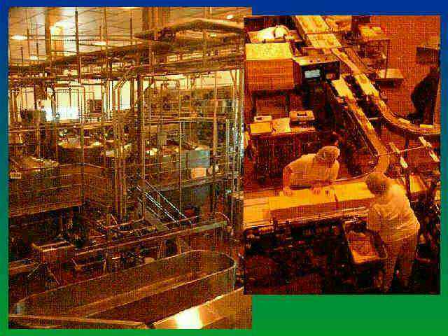
I made yet another visit to the Tilamook cheese place on the way south. Somehow the whole thing still entertains even though it has become as much of a tourist trap as a food production facility. One of our pictures for the day is of the cheese processing vats with an inset of beginning of the packaging process. I have it on good authority that the women in the foreground cut the cheese for eight hours every day with only a short break for lunch. (sorry about that, too many years in the AF left me with a sick sophomoric sense of humor).
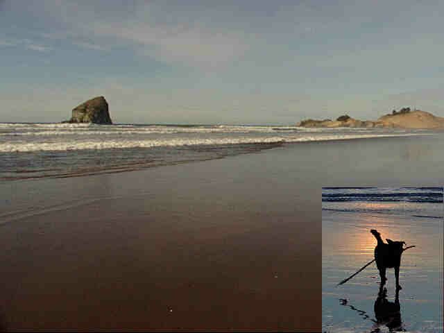
By way of making up for the last couple of nights, I got a really decent motel room tonight for a decent price (and it has phones I can use!). This place is just north of town and sits right on the water. I walked on the beach for a while after dinner and made an unexpected friend (see inset in second picture). This old dog wandered down the beach toward me. As I got close to a piece of driftwood, he stopped, looking first at me and then at the wood expectantly. I had never been a dedicated viewer of "Lassie" but eventually I got the message "throw this stick for me, please". I tossed it up the beach and he brought it back. I tossed it down the beach and he brought it back. I got mean and threw it into the surf and he brought it back. After six or seven times I got tired of the game and refused to throw any more and he took off down the beach carrying the stick and looking for another thrower.
The main part of the second picture is the view up the beach at Pacific City, Oregon. Quite pretty up there around lunch time as the fog had cleared by then.
It is about 200 miles to the California border from here. With luck I'll not find things too interesting to prevent me from making it at least that far or a bit more. Eventually I'll have to strengthen my resolve and avoid stopping at every small-town museum and roadside attraction and press on with our 12,000-mile tour of the edge of the USA.
Day 15, October 25, 1997: Yachats, OR to Eureka, CA
↑ ↓ Today was a travel, not a look-n-stop day. Fortunately the major attraction along the way was the redwoods and I know from experience that photographing them is a lost cause since there is no good way to convey the scale of the subjects.
 I got into Eureka early enough to get into the motel, eat, and then take a
walk around what they call the "old town" area. I took a few pictures for my collection of architectural excess. Today it was the
old Carson mansion, now a private club. The details of this late 1800s house defy description so I'll be sure to include it
some day when there is nothing else to show. Let is suffice to say that it can be described as grotesque victorian on a bad LSD
trip.
I got into Eureka early enough to get into the motel, eat, and then take a
walk around what they call the "old town" area. I took a few pictures for my collection of architectural excess. Today it was the
old Carson mansion, now a private club. The details of this late 1800s house defy description so I'll be sure to include it
some day when there is nothing else to show. Let is suffice to say that it can be described as grotesque victorian on a bad LSD
trip.
The single picture for today is taken at Natural Bridges Cove in Oregon. I almost regret not hiking down for a closer look but from the looks of the "trail" it was down a near-vertical cliff with no sort of protection provided. Then again that might have been some trail left behind by mountain goats.
By tomorrow I'll be in the San Francisco area but because of bad timing it will probably be impossible to get to see my intended "visit-ee" there because of her work schedule. Guess we'll work something out somehow, though. I do want to get down to Silicon Valley for some shopping and that will take up a day in any case.
Thus goes our 12,000-mile tour of the edge of the USA.
Day 16, October 26, 1997: Eureka to Fort Bragg, CA
↑ ↓ If I were to become really pretentious and start adding subtitles to these messages, today would have to be "The road less traveled". Gawd, what a tiring messy day! I started out fine leaving Eureka early because of the time change, headed south, found my first turnoff and then things quickly got stressful.
My route called for me to go through Ferndale, a nice little Victorian (yes that word again) town which has a real sense of its own history. Nothing pushy about them, it is just there for you to look at as you wish. Leaving Ferndale, I was supposed to go to a town called Petrolia. If you look for it on a map and are lucky enough to find it, you'll notice that it is really near nothing else and that is not stretching the point. The road between the two towns is about the twistiest turningest pieces of work I've ever seen; about enough to induce motion sickness in a mummy. I'd estimate that the longest straight stretch for 30 miles was about 30 yards. The road follows ridges through rolling terrain and rises and falls several thousand feet to boot; my ears were popping through the entire thing. There were some truly stunning views as reward along the way including a stretch of road that traverses the loneliest stretch of Pacific beach I've ever seen; it was just me and a few score cattle for miles. Petrolia has a fantastic remote beach that would be heavenly for those wanting to camp in seclusion although getting there is a bit of a pain.
 I got to a point where the route the computer was calling for was
impossible due to road washouts. The previous road had a few places where one lane of the road had disappeared down a gully but
the next stretch was completely gone in places. For that reason, I had to ad lib a bit (and yes I did get a bit lost in
backtracking through these unmarked roads even with a GPS) and that took me in a round-about way to my destination on the coast:
Shelter Cove. Well, it turns out that this town is a real treasure but so far away from anything that it is amazing it is able to
exist. It appears to be very prosperous community with beautiful homes and all that but since it is 20 miles of frightful road
from the nearest highway the fact that it exists seems a miracle. (as an example, the only place in town to buy gasoline sells it
for almost $2.00 a gallon) Shelter Cove has its own secluded beaches like Petrolia as well as major coastal hiking trails and the
biggest bunch of pelicans I've ever seen.
I got to a point where the route the computer was calling for was
impossible due to road washouts. The previous road had a few places where one lane of the road had disappeared down a gully but
the next stretch was completely gone in places. For that reason, I had to ad lib a bit (and yes I did get a bit lost in
backtracking through these unmarked roads even with a GPS) and that took me in a round-about way to my destination on the coast:
Shelter Cove. Well, it turns out that this town is a real treasure but so far away from anything that it is amazing it is able to
exist. It appears to be very prosperous community with beautiful homes and all that but since it is 20 miles of frightful road
from the nearest highway the fact that it exists seems a miracle. (as an example, the only place in town to buy gasoline sells it
for almost $2.00 a gallon) Shelter Cove has its own secluded beaches like Petrolia as well as major coastal hiking trails and the
biggest bunch of pelicans I've ever seen.
Things quieted down a bit after I left Shelter Cove and, for virtually the first time today, knew precisely where I had to go: back to 101 and look for the turnoff for route 1 on the coast. The road down to the coast was another sick-maker like the one to Petrolia but in better condition (not even once did it slide down the cliff ). Getting to the coast was a great relief in any case and the drive down to Fort Bragg was trivial. I remember this town as the place I wound up on Thanksgiving Day of 197? after my first cross-country drive. It has grown quite a bit since then and I wouldn't have recognized it from my old memories. In any case it has motels, restaurants, supermarkets, and a car wash so my needs were met.
Picture of the day is along the previously mentioned stretch of solitary beach between Ferndale and Petrolia. The whole section of the coast north of the Mendocino is called the "Lost Coast" and the reason is clear to me now. There is almost no way to get to the coast by highway and when you manage to make it you are likely to find yourself alone.
Tomorrow, I will probably wind up on the El Camino Real in the Silicon Valley near where I used to live. I really love to go techno-shopping and you would be hard pressed to find a better place to do it. Besides there is this really fantastic Afghani restaurant I know of...
Thus goes our 12,000-mile tour of the edge of the USA.
Day 17, October 27, 1997: Fort Bragg to Sunnyvale, CA
↑ ↓ If I discovered anything today, it is that I am probably ruined for driving in heavy traffic by too long a stay in the boonies of Alaska. The drive down through San Francisco really bothered me this afternoon as it never has before. The radio traffic reports were calling traffic light and waxed eloquent about how well everything was going. If that was good, I might never survive bad.
 Good news was that the weather was so beautiful that I put the top
down for the majority of the drive today. I did the same yesterday and toughed it out without any sunscreen since there was a bit
of haze. Today the sky was perfectly clear so I stopped in one of the little resort towns along the coast and found a bottle of
something to keep my tender bod from being parboiled.
Good news was that the weather was so beautiful that I put the top
down for the majority of the drive today. I did the same yesterday and toughed it out without any sunscreen since there was a bit
of haze. Today the sky was perfectly clear so I stopped in one of the little resort towns along the coast and found a bottle of
something to keep my tender bod from being parboiled.
The road down from Fort Bragg was pretty typical of the northern coast with some extremely twisting slow sections interspersed with coastal towns. One of the prettiest little towns is surely Mendocino even though it has become a tourist trap as outrageous as any in the country. Even the yuppification of the old town hasn't taken the shine off of it for me.
The last section of the coastal highway, from Stinson Beach up to the juntion of 101 could be used as a stress test. The road is as twisty as what comes before but adds the thrill of clinging to a virtual cliff with almost no protection. Make a slip there and you get a very quick lesson on the aerodynamics of your vehicle in free-fall as you hurtle downward.
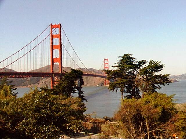
The picture for today is, well if you don't know I'm not going to tell you. I understand that there is a new law that requires every tourist coming to the city take this exact picture or purchase a suitable postcard containing same under penalty of law. Being a law-abiding sort I did my duty.
Right now I have no idea what will come tomorrow. Obviously, having come this far to visit someone I don't want to leave without doing it. I can probably stand one more day bumming around Silicon Valley (and I have yet to make it to the Afghani restaurant) and then I will head over to Pacifica to see what develops. If nothing else, Pacifica is in a pretty area of the coast just south of SF and I can poke around there until something develops.
Thus goes our 12,000-mile tour of the edge of the USA.
Day 18, October 28, 1997: Sunnyvale to Pacifica, CA
↑ ↓ Pretty much a non-day today. Didn't travel very far, didn't see very much, didn't do very much.
Before leaving Silicon Valley I got a bit of shopping done. There is a cluster of high-tech stores in Sunnyvale right off of the Lawrence Expressway that offers almost anything you might want in the way of electronic equipment or components - almost like Tokyo's Akihabara district but under fewer roofs and with more glitz. The key to the whole experience is Fry's which is an electronics / entertainment / computer supermarket and is frequented by all the tech-heads in the valley. Immediately across the street is a newcomer, the T-Zone which is Japanese-owned and offers great computer shopping. Also in the area are several smaller specialty stores offering surplus and specialty items. I actually only bought a couple of items (a security cable and a 32meg of memory for my laptop) but the browsing experience was pleasant. The fact that the memory was available off-the-shelf instead of by mail-order was a pleasant change since laptop memory is far from being a commodity item and is often difficult to obtain.
 I had a dining revelation at lunch time before leaving the
valley and discovered that a burrito can be a gourmet delight - haute as well as hot cuisine. I saw this little Mexican restaurant
called Bueno Bueno! that seemed to be doing a booming business with the locals. They sell burritos almost exclusively and I sampled
one (they are huge) of their standards. It was absolutely superb, being made with the freshest ingredients and spiced perfectly. I
regret now that I won't be able to get back there for another bite. Note: This business seems to have closed ten years
after my visit so that guarantees I won't be going back no matter what.
I had a dining revelation at lunch time before leaving the
valley and discovered that a burrito can be a gourmet delight - haute as well as hot cuisine. I saw this little Mexican restaurant
called Bueno Bueno! that seemed to be doing a booming business with the locals. They sell burritos almost exclusively and I sampled
one (they are huge) of their standards. It was absolutely superb, being made with the freshest ingredients and spiced perfectly. I
regret now that I won't be able to get back there for another bite. Note: This business seems to have closed ten years
after my visit so that guarantees I won't be going back no matter what.
The drive to Pacifica was uneventful except for the inescapable road work. I eventually got to see Lehua for a half hour after prying her away from her work. She is currently stuck working on "The Project from Hell" for her bank and, although she telecommutes, she seldom even finds time to sleep because of it. We did arrange to have dinner in San Francisco on Wednesday evening but that will be the extent of our visiting it seems. Oh well, maybe some other time...
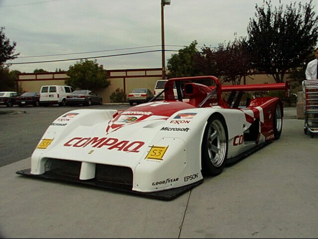
The picture for today is a piece of rolling advertising that was sitting outside of Fry's in Sunnyvale - the Compaq Ferrari.
Wednesday will be a non-travel day also but I hope to do a bit of looking around in San Francisco. One thing for sure, I'll have to look for a different motel room as this one in Pacifica is just too noisy because it is close to the freeway.
Thus goes our 12,000-mile tour of the edge of the USA.
Day 19, October 29, 1997: Pacifica to Mountain View, CA
↑ ↓ Yesterday I said that I wouldn't be doing much traveling today. Well, that might have been an understatement since I did a lot of driving around, just didn't make any progress down the edge.
 Finding a motel room, at least a relatively affordable one, that I liked proved to be difficult. I had figured that getting out
of Pacifica and up to Silicon Valley again would make things easier but it seems that something of a motel room crunch is
developing up here too. I finally lucked into a nice room in a new motel, and although it wasn't a non-smoking room as I
normally require, it was so new that it hadn't acquired any odors to make my allergies act up.
Finding a motel room, at least a relatively affordable one, that I liked proved to be difficult. I had figured that getting out
of Pacifica and up to Silicon Valley again would make things easier but it seems that something of a motel room crunch is
developing up here too. I finally lucked into a nice room in a new motel, and although it wasn't a non-smoking room as I
normally require, it was so new that it hadn't acquired any odors to make my allergies act up.
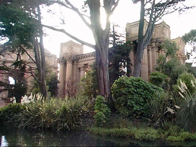
Beyond moving, today was taken up with San Francisco. I drove back up to the city and parked in my "sure thing" free parking area at the Exploratorium. I did the museum tour and took a few pictures at the Palace of Fine Arts (this is one of the other obligatory photos that all tourists must take) and then took off on a walk down the waterfront.
All told, I probably walked at least three miles down past the marina, the green, and Fort Mason (and back of course which wasn't nearly as much fun). This is a great walk for admiring the eclectic architecture in the city. Since I don't know anybody with enough money to actually afford one of these homes (actually if everybody I know put their money together, they could probably only afford the cheapest among them) I have never seen the inside of one. The outsides sure are pretty, though.
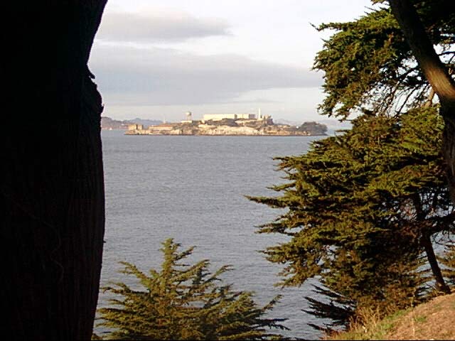
I had arranged to meet Lehua for a drink and a nosh out at Cliff House by Seal Rocks. I had plenty of time to get there but my city navigation skills proved not to be up to the task. After bumbling around for a half hour, I bowed to the inevitable and got the laptop out of the trunk and hooked it up to the GPS. It got me on the right track (and more importantly to Geary Street) and I was able to find my way after that. The area of Cliff House was completely new to me although I used to live only a short distance away. This is a great loss to me as this coastal area is fascinating - I really regret getting there after it was so dark. It must be sensational during the day and at sunset. I also discovered some unexpected wildlife virtually at the restaurant's door. It was too dark to see the seals, assuming they were out on their rocks, but right in front of me was a (herd? pack? mob?) of city raccoons. They would let me get within five feet of them, but since I offered no food they limited me to that.
Well, Lehua had our bit of time to talk away from her job but it was soon over and time to find my way back south to the motel. Driving in the evening proved to be a bit less painful than during the daytime and I got through without getting lost or injured.
Pictures for today are two of the other obligatory San Francisco landmarks that anybody, even those who have never been here, will recognize...
Tomorrow we will get back on the move and continue our 12,000-mile tour of the edge of the USA by heading down the coast again.
Day 20, October 30, 1997: Mountain View to Buellton, CA
 ↑ ↓ I am where I am because of the soup. Pea
soup. Andersen's pea soup to be precise. For some reason the memory of having a bowl of very good pea soup while on a trip to
Vandenberg AFB a couple of decades ago got me off of my intended track which would have put be in Santa Barbara tonight and
landed me in the middle of farm fields. Believe it or not, people come from all over to eat this soup and there are even bus
tours on a regular basis. As it turns out, the soup tonight, while good, couldn't match my memories. Then again, few things
do...
↑ ↓ I am where I am because of the soup. Pea
soup. Andersen's pea soup to be precise. For some reason the memory of having a bowl of very good pea soup while on a trip to
Vandenberg AFB a couple of decades ago got me off of my intended track which would have put be in Santa Barbara tonight and
landed me in the middle of farm fields. Believe it or not, people come from all over to eat this soup and there are even bus
tours on a regular basis. As it turns out, the soup tonight, while good, couldn't match my memories. Then again, few things
do...
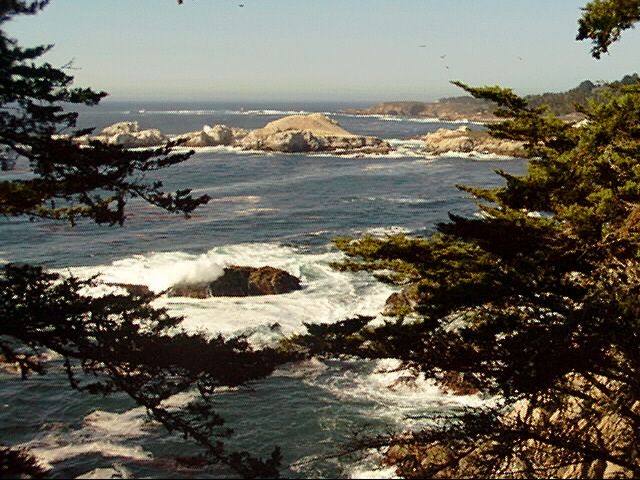
Today was a top-down drive from Big Sur south. The weather was superb when I put the top down and stayed good until the sun went down. Around then it started to feel a bit clammy in the car but the ride was worth the little bit of discomfort at the end.
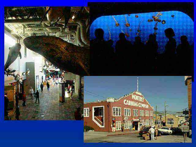
The high point of the day was Monterey. Actually the Monterey Bay Aquarium. The other attractions such as Cannery Row, ala Steinbeck, were overly-hyped tourist traps. The aquarium made up for all of that - it is surely the best of its kind. I'm afraid that there aren't any good pictures of the most impressive displays since the light was rather dim and flash is unkind to the fishes. I urge anybody heading up or down the coast to go and see it for themselves. You won't regret it.
Pictures for today include a montage of some usable aquarium pictures and cannery row; the other is one of those "this must have been faked" coastal shots taken around Carmel.
Tomorrow will find me somewhere south of Los Angeles (which I will get through/around as quickly as possible) as we continue our 12,000-mile tour of the edge of the USA.
Day 21, October 31, 1997: Buellton to Leucadia, CA
↑ ↓ If you want to figure out where I am, take a look at
a map but it might not help much. 
 Leucadia is a tiny beach community about 20 miles north of San Diego. The
upshot of this is that I will be able to get down to Border Fields State Park south of San Diego at a reasonable hour, locate the
southwestern-most corner of the contiguous US and finish my first edge. Two more to go after that. Who knows, I might even find
my way out of California by tomorrow evening.
Leucadia is a tiny beach community about 20 miles north of San Diego. The
upshot of this is that I will be able to get down to Border Fields State Park south of San Diego at a reasonable hour, locate the
southwestern-most corner of the contiguous US and finish my first edge. Two more to go after that. Who knows, I might even find
my way out of California by tomorrow evening.
The drive south today was, shall we say interesting, just to keep it clean. The beginning was screwed up by yet more road closures which forced a considerable backtrack. Later on I missed a few turns that I should have made because the strong sunlight made it impossible to read the computer screen. This caused me to miss one of my scheduled stops: Honda. I don't know what is there, but it was out there on the edge and I missed it and didn't discover the problem until it was too late to go back. Then came the good part: the San Diego freeway.
For any of you who haven't driven this jewel, try to imagine a huge highway. No, no, bigger than that! Try ten lanes as a minimum sometimes expanding to eighteen lanes. Now imagine all of these lanes filled with vehicles which never drop anywhere near the 65mph speed limit. Any vehicle traveling that slowly is as good as crushed. Now throw in random instances where all this hurtling metal comes to unexplained screeching halts. That seems a pretty fair description. Now image me driving down this highway with my top down slowly baking my brains and wishing that I had gotten the air conditioning for the Miata, Alaska car or not.
Only one set of pictures today. This is Mission La Purisima located a bit north of Lompoc. Actually the closed road this morning led me to it which I guess makes it a bit of luck. The mission as it stands is one of the most complete in the state. This is actually the second mission in the area, the original 1780s mission having been wiped out by an earthquake. This later mission was built around 1820. Every time I see one of these early sites it leaves me wondering what life on this frontier must have been like. There are always more questions posed that answered by the displays they provide.
Tomorrow should find me somewhere in the desert heading east and I will definitely not have the top down as we continue our 12,000-mile tour of the edge of the USA.
Day 22, November 1, 1997: Leucadia, CA to Yuma, AZ
↑ ↓ Today was a turning point. Literally. I got to the southwestern-most corner of the contiguous USA and made a left turn. Those of you have known me for a while and have thought that I was "around the bend" may rest assured that it is now certifiably true.
I got to what appeared to be the proper point without too much difficulty this morning. I snuck through San Diego without too much trouble by starting early. Traffic was tolerable, especially when compared to that I faced yesterday (this was early on a Saturday morning, after all). Finding Border Field State Park proved to be fairly easy but as parks go, it is not a place I'd want to go for a picnic. It is a desolate, dusty backwater stuck into land at the corner of the Mexico/USA border and the Pacific. Officially it is on the Tijuana Estuary, the body or bog or whatever that appeared to be a great breeding place for biting flies which harassed me constantly. In any case, my stay was short.

 That bit of work done, I pressed on along the
computer-determined course. There was a bit of a foul-up with an unmarked highway but that was straightened out and into the
desert I went. There was a pretty much steady climb at first in the 80+ then 90+ degree heat. This revealed that my car has a
dislike for severe work in high temperatures and the temperature gauge crept slowly toward the overheat point. The car never
actually malfunctioned in any way but it was worrying. I suspect that the re-engineering I did on the front license plate
mounting (moving it downward) may be blocking the airflow and causing this problem. If so, it will be easy to correct if it
happens again.
That bit of work done, I pressed on along the
computer-determined course. There was a bit of a foul-up with an unmarked highway but that was straightened out and into the
desert I went. There was a pretty much steady climb at first in the 80+ then 90+ degree heat. This revealed that my car has a
dislike for severe work in high temperatures and the temperature gauge crept slowly toward the overheat point. The car never
actually malfunctioned in any way but it was worrying. I suspect that the re-engineering I did on the front license plate
mounting (moving it downward) may be blocking the airflow and causing this problem. If so, it will be easy to correct if it
happens again.
Not so easily ignored was the heat inside the car. I guess that I have become a real wimp, but the temperature was really getting to me. Driving along in the high desert, looking out at the dusty scrubby landscape a couple of miles north of the border I kept thinking "out of the frying pan into el fuego". Without a doubt, one of the first things I do when I get to Tennessee will be to find the AC parts from a wrecked Miata and have them transferred to mine. Enough is enough.
The heat was bothersome enough that I cut my drive short a bit early. In fact when I saw a roadside sign for Motel 8 (my favorite low-price chain) in Yuma touting their pool, etc my mind was made up. In Yuma it proved to be only 84 degrees but it was certainly sufficient to take some pool time. Despite the chance of offending the local sensibilities with my pale bod, I was in the pool soon after checking in and it was wonderful.
Throughout my drive today I noted one fact that should have been predictable. The biggest governmental presence in this area is, by far, the Border Patrol. Their vehicles are everywhere and I drove past three separate large complexes of theirs just today. In my short stay at the park this morning I was checked out twice by agents. Not doubt if I didn't have my Swedish/Scottish/Irish/German coloration their observations might have been even closer. Another interesting item which I tried and failed to photograph was the "running alien" signs along the major highways. These show the profiles of a running man and woman with a small child in tow. It seems that many illegals were being killed while trying to run across the interstates at night. They have signs for deer, so this is probably a reasonable precaution (but it does still seem odd). I only made one "lookie" stop today and that was disappointing. I had found mention of the San Diego Railroad Museum stuck in a backwater desert town to the east of the city and had high hopes for it since the city does its zoos so well. Unfortunately it was a real bust since they wouldn't let me browse even the limited rollingstock and their rides were short and done on rather modern equipment. If you want to see a really good RR museum, I'd suggest you try the Nevada State Railroad Museum in Carson City or the Pennsylvania Railroad Museum in Strasburg. Either of these is excellent.
Today was almost a total bust as far as pictures are concerned. The montage shows an area of huge dunes near the California / Arizona border where thousands of people come over the weekend to ride their off-road vehicles as well as the sole picture I snapped at the railroad museum. The other picture is the same old mission from yesterday.
Tomorrow I will deviate from the "edge" route and head north to locate the longest remaining section of old Route 66, just for old times sake. This side trip will take two or three days but I will get back to the Mexican border right after that and continue eastward as we continue our 12,000-mile tour of the edge of the USA.
Day 23, November 2, 1997: Yuma to Seligman, AZ
↑ ↓ Get your kicks on Route 66... Well, I can't admit to having any kicks today but I did enjoy driving on that famous route again. Actually I'm staying the night at the "Historic Route 66 Motel" in Seligman, the eastern point on the longest remaining section of highway. It seemed appropriate to stay at this old motel rather than look for a modern one in Flagstaff. This motel clearly has been here for many decades and the semi-deco look and plumbing aren't the only clues. Many of the rooms have plaques on them of the "Washington Slept Here" variety. Mine says that Will Rogers Jr. slept in this room, another hosted Burl Ives, and other lesser luminaries stayed in other rooms. Even Martin Milner, star of the old Route 66 TV series stayed here.

 Driving north from Yuma took me from high to
higher desert with occasional dips to the low and hot places. Fortunately the hot spells were not as bad as yesterday's.
Seligman is actually at almost exactly one mile altitude and the weather was quite pleasant when I got here and might actually
dip into the 40s tonight.
Driving north from Yuma took me from high to
higher desert with occasional dips to the low and hot places. Fortunately the hot spells were not as bad as yesterday's.
Seligman is actually at almost exactly one mile altitude and the weather was quite pleasant when I got here and might actually
dip into the 40s tonight.
On the way north I was within a short distance of the Colorado River. Water in the desert attracts one thing more than any other - people. There are communities on the river and the series of artificial lakes on it including Parker and Lake Havasu City. Parker Dam was originally meant for power production and irrigation but it is now a magnet for tourists and retirees.
Even more amazing is Lake Havasu. The town there wasn't started until 1964 and the current population is around 30,000. Even more amusing to me is that part of the city's attraction is based on ignorance (or fraud depending on how you look at it). In the early days, a developer was looking for some sort of attraction and finally settled upon the "London Bridge". Well, it was London Bridge, condemned by the city government as not worth keeping. The local developer purchased it for a song, had it torn apart, and reassembled in the desert. The ignorance comes into the story because most people hearing "London Bridge" visualize "Tower Bridge" and rush to Lake Havasu to see this amazing structure. What they get is a plain stone bridge with very little to recommend it artistically or historically. Now one can see such attractions as "The World Famous English Village" which is actually a shopping mall. Even routine buildings in the area feature faux castle architecture with crenelated towers. Gack!
Another new sight for me were the "long term visitor's areas" along the highway. These are spaces in the desert set aside for motor home and trailer parking for a seemingly huge number of northerners who "snowbird" down to warmer climes for the winter. These areas sometimes extend for miles along the highway and vehicles can be seen dotting the landscape for miles back from the highway. Allowing that these spaces feature no water, no sewage system, no power, no telephone, no mail delivery, it must take a special sort of dedication of or desperation to stay there for months on end. I hate the cold as much as any person might, but even I wouldn't put up with that for too long. Guess I'm just spoiled.
Two pictures today. The first shows the sort of image that pops into my alleged mind when I hear the word "Arizona". The other shows a through-the-windshield view of old Route 66>. Even after all these years it looks pretty much the same as the first time I drove it back in 197?. One missed picture is of the highway sign telling motorists that they are crossing "Holy Moses Wash". I really should have gone back to take that one to add to my collection but was too lazy.
Actually, the old stretch of highway probably looks about the same as it did in 193?. It seems a shame that so much recent history was lost when the old route was abandoned. One attraction, though, is doing business in the same location: The Grand Canyon Caverns. It is still there, still tacky, and still worth a stop if you are in the area. Where else might you take an express elevator ride down into the bowels of the earth and see a naturally mummified bobcat in a cavern? The 45-minute guided tours leave every half hour as they have for the past 40-or-so years and the price is still under $10.
Tomorrow I will head south again to get back on the edge via a tricky route the computer chose for me. Ever the optimist about its abilities, I'm going to try to stay with that route even though it seems to go through some strange backwaters (or perhaps in Arizona backrocks or backsagebrushes might be more appropriate). The trip back down to the border may well take longer than the trip north but there is no hurry about making it back as we continue our 12,000-mile tour of the edge of the USA.
You will be receiving this e-mail at least a day late as this old motel has a frustratingly modern digital telephone system that will not work with a modem.
Day 24, November 3, 1997: Seligman to Globe, AZ
↑ ↓ I received an inspiration this morning to change my route a bit and decided to go and look at the big hole. No, no, not the Grand Canyon. That other hole that was a standby to old Route 66 travelers - the Great Meteor Crater. Anyway, I really prefer the north rim over the sourth rim of the Grand Canyon and have been there too many times as it is.
 Re-routing to the crater called for a lot
more driving on I40 than the original route would have. Driving along through the high scrubby terrain at 75mph doesn't allow
for much sightseeing so it is good that there isn't much to see. I got to the crater at 9:30AM, a bit later than optimal for
the best lighting. In any case the zoom lens on my little digital camera isn't sufficient to take in the whole crater from
the available vantage points so no "big picture" was possible.
Re-routing to the crater called for a lot
more driving on I40 than the original route would have. Driving along through the high scrubby terrain at 75mph doesn't allow
for much sightseeing so it is good that there isn't much to see. I got to the crater at 9:30AM, a bit later than optimal for
the best lighting. In any case the zoom lens on my little digital camera isn't sufficient to take in the whole crater from
the available vantage points so no "big picture" was possible.
After the crater, I drove south but instead of being on back roads as my original routing would have produced I was on fairly major state roads. The route took be over some very high pine-covered areas, sometimes over 7,500 feet. This gave me pleasantly cool temperatures which lasted almost until drive's end. There were several very pretty canyon scenes along the way down Arizona 77 looking like miniature Grand Canyons. The largest and most impressive was Salt Canyon but the prettiest was an unnamed one further north that looked like a great picnic spot except that there was no way down the several hundred feet of cliff separating the road from the stream and forest below.
I wound up in the town of Globe by default: I didn't feel like driving any more and they had motels and restaurants. Case closed. I did have an interesting meal at a Mexican restaurant called Irene's which claims generations-old recipes. The red chile was a real revelation and had somebody served it to me with chapates instead of tortillas, I'd have sworn it was north-Indian cookery. The spicing was totally unlike any Mexican food I've had before.
One unexpected benefit of stopping here was the discovery of Besh-Ba-Gowah, the archeological dig of a village that was abandoned around 1400. The name given is Apache in origin since they were the only ones around the site when the first European explorers appeared on the scene. The Apaches didn't really know anything about it either and simply made up what they thought was a good name. Studies have shown that the builders were fairly advanced people who traded and travelled widely. If you have an interest in southwestern cultures, this is a must-see.
Only one picture today, a partial view of the Meteor Crater from the rim.
Tomorrow I'll be heading toward the Mexican border via Wilcox and Douglas. That should get me into some old western history along the way as I continue the 12,000 mile journey around the edges of the USA.
Day 25, November 4, 1997: Globe to Douglas, AZ
↑ ↓ Today had the potential to be a major disappointment. The terrain through which I was driving was boring squared. There were, for the most part, no towns. One place served to make the whole thing worth while: Chiricahua National Monument.
 Before today, I didn't even
know that this place existed. To me Chiricahua was the name of a band of Apaches and nothing else. It turns out to be one of the
most delightful natural places I have visited. If you have been to one of the Utah "big rocks" parks such as Zion you can
probably understand Chiricahua - it is about the same thing but on a smaller scale but where you can actually get down and touch
the good stuff.
Before today, I didn't even
know that this place existed. To me Chiricahua was the name of a band of Apaches and nothing else. It turns out to be one of the
most delightful natural places I have visited. If you have been to one of the Utah "big rocks" parks such as Zion you can
probably understand Chiricahua - it is about the same thing but on a smaller scale but where you can actually get down and touch
the good stuff.
The main road through the park takes a path through a very narrow canyon where the trees and rocks tower only yards away on either side. The stone formations themselves are fantastic in the extreme. Those weird formations and balancing rocks so prevalent in the Roadrunner cartoons are real here. Balancing rocks easily number in the hundreds. Some formations seem to defy gravity for surely nothing so unbalanced looking could be standing.
There is a great assortment of wildlife in the area. I had my first opportunity today to see coati mundi in the wild. The ones living in the park, while not tame, are not overly fearful of man. Although I didn't manage to get a picture good enough to share with you they were definitely within photographic distance. On one instance, a pack (herd? mob? group?) of them approached within a couple of yards of the car while I was sitting in it transferring pictures from the camera to the computer. Unfortunately, while doing this I was unable to use the camera. After the transfer was done, at the first sign of movement they scattered into to brush. They seem to have been signaled by a leader which was wearing a radio collar. He gave a series of grunts/coughs when he saw me moving and they vanished. As I was sitting quietly in the car an unable to actually do anything the animals were amazingly noisy rooting through rocks and fallen leaves but after they knew I was there they were totally silent.
The coati mundi aren't the only "Mexican" wildlife in the park. There are several bird species seen nowhere else in the US living in the park just as they do in the Sierra Madres down south.
Photographing in the park is frustrating for the same reason that photographing the redwoods is - they are just too big and too close to allow any scale to be shown. I have given up on the redwoods for this reason. Take a picture and show it to someone who doesn't know about them and tell them that the base of the tree is the same diameter as the length of two Miatas (26 feet) and they will simply glaze over. In the park the rocks are so close and tower so high above you that you can't tell if they are six feet or six hundred feet high. In any case I am sending one attempt at the formations just to show that I tried.
I urge anybody traveling through the southwest to make a detour to Chiricahua and try it. Pack a lunch and the family. Wear your hiking boots (there are 20+ miles of trails). Take your camera (you might do better than I did). It is an amazing bargain at the $6.00 per car entry charge!
One major disappointment was finally seeing the town of Willcox. A couple of years ago I was researching places to retire and was a hair's-breadth away from purchasing land there, sight unseen. From the descriptions, it was an earthly paradise. The reality doesn't, to put it very kindly, live up to the hype. I can see why they are trying to attract people though. The downtown seems to be dying bit by bit. There are many empty storefronts and the two auto dealers have given up. The wonderful orchards and farms that were described turn out to be many miles from the town. I guess in the case of the Willcox land purchase, I did the right thing by doing nothing.
As I write this I am in Douglas, Arizona which is about a mile north of the Mexican border. For all practical purposes it might was well be a mile south of the border. In all regards, this is a Mexican town that just happens to be a bit misplaced.
Tomorrow I will press on toward the east into New Mexico. I suspect that I will see very little to slow me down along the way. The southern part of that state is not known for attracting tourists. If it proves as uninteresting as I fear, I might well be in Texas before I stop tomorrow. I had better give the Buckbees in San Angelo a call to warn them that the northern invader approaches their border as I continue the 12,000 mile journey around the edges of the USA.
Day 26, November 5, 1997: Douglas, AZ to El Paso, TX
↑ ↓ Yesterday I said "Today had the potential to be a major disappointment. The terrain through which I was driving was boring squared. There were, for the most part, no towns. ..." Well, if the yesterday had the potential, then today fulfilled its potential and was a general downer. And if the terrain was boring squared then today managed to achieve cubed. The high points today consisted of an oil change and an office supply purhcase.
 The drive out of Douglas was
through the most uninteresting terrain I have seen to date - mainly open grassland with a bit of scrub here and there. Add a cow
every few square miles and you have it. The wildlife consisted of a few hawks and one roadrunner.
The drive out of Douglas was
through the most uninteresting terrain I have seen to date - mainly open grassland with a bit of scrub here and there. Add a cow
every few square miles and you have it. The wildlife consisted of a few hawks and one roadrunner.
The distance from Douglas to El Paso proved to be about 200 miles. Since the car was in need of an oil change and I needed some ink cartridges for my printer. I decided to stay here for the night so I could take care of these chores. The oil change was easily achieved. Finding and purchasing the cartridges entailed driving around for hours in traffic and very nearly defeated me.
Tomorrow will doubtlessly be better than today. I have decided that, since I am in the area (well, if you have a liberal interpretation of "in the area" anyway) that I will go to Carlsbad Caverns up in New Mexico. It is a three hour drive away. For this reason I have booked this same room for tomorrow night also. I talked to Grace Buckbee on the phone and arranged my visit to them in San Angelo, now booked for Friday.
There was not one good picture today to include so I will dig back into the archives and show you the picture from Eureka, CA of what I thought was about the ugliest Victorian-style mansion I can imagine. You can make up your own mind about it.
And the 12,000 mile trip rolls on and starts to look like it will be a 13,000 mile trip as I add branches and backtracks to my route.
Day 27, November , 1997: Carlsbad Caverns, NM
↑ ↓ Today was a round-trip sightseeing day. I'm back in the same room tonight that I was in last night. This isn't a bad thing since it is a very nice room in a new motel, and rather inexpensive to boot.
 The drive out to Carlsbad Caverns from El Paso goes through about the same sort of terrain as I wrote about
yesterday - boring and desolate but with an important exception. This grand exception is the Guadalupe Mountains. My impression of Texas has always been of a rather flat place with
barely the energy to rise up into a ripple. This place is certainly an exception with the highest point in Texas - Guadalupe
Peak. This isn't a flashy mountain and has no way of competing with its slightly shorter neighbor, the 8,000 foot El Capitan.
Today's picture is of El Capitan with Guadalupe Peak in the background. There is a national park here with some beautiful
sheltered habitats in the canyons that are unlike anything surrounding them.
The drive out to Carlsbad Caverns from El Paso goes through about the same sort of terrain as I wrote about
yesterday - boring and desolate but with an important exception. This grand exception is the Guadalupe Mountains. My impression of Texas has always been of a rather flat place with
barely the energy to rise up into a ripple. This place is certainly an exception with the highest point in Texas - Guadalupe
Peak. This isn't a flashy mountain and has no way of competing with its slightly shorter neighbor, the 8,000 foot El Capitan.
Today's picture is of El Capitan with Guadalupe Peak in the background. There is a national park here with some beautiful
sheltered habitats in the canyons that are unlike anything surrounding them.
Carlsbad Caverns are truly impressive. The main underground room covers an area equivalent to 14 football fields with many large branches extending from it. There are paths with guardrails all over this room and tourists are allowed to wander as they desire in this area. Other areas are limited to guided tours only and for the really hardcore it is possible to get permission to travel through some totally undeveloped areas (if you can prove you are likely to survive, anyway). The main room is around 750 feet underground. The deepest branches where anybody is allowed to roam are some 300 feet deeper.
A couple of things caught me unawares down below. One was the humidity. I knew that the temperature stayed at 56F in the cavern but I didn't realize what the 100% humidity would be like. Talk about feeling clammy! I had to take my jacket off after about ½ mile because it was soaked. The other problem was photographic. They are pretty stingy about the light down below, which is supposed to be to prevent algae from growing on the damp surfaces. The eyes adapt to the low level readily but for photography it stinks. Flash is useless, regular amateur-type flash anyway, because everything is so bloody big. For this reason, I'm not offering you any pictures from down below - the best of them is pretty awful.
The Caverns contain all of the things you'd expect in this sort of place with a great number of formations from the minute to the massive. Damn, I wish I could have photographed them, though.
Tomorrow I will be heading toward San Angelo, TX for a couple of days visit with the Buckbees, old friends of mine from Alaska. Bill was my boss in the Air Force some uncountable number of years ago but I didn't hold that against him and we became friends anyway. It is a six hour drive from El Paso to San Angelo and I have no idea what lies in between except that I've been told that the birthplaces of both Buckbees lies along the highway (although Grace's hometown was torn down and moved by the oil company that owned it literally leaving only the streets behind).
After a couple of days in San Angelo I will continue the 12,000 mile journey around the edges of the USA.
Day 28, November 7, 1997: El Paso to San Angelo, TX
↑ ↓ As I write this I am several days behind on my writing. It is actually November 9th and I am in Eagle Pass, TX.
The drive out from El Paso to San Angelo was about half Interstate and half state highway. In either case the roads are good and speed limit high. Unfortunately, for most of the trip there was really nothing of note, or at least nothing worth photographing for posterity.
On the state highway portion of the drive I traveled through a handful of towns that were once in the core of the west Texas "oil patch". Today all of them are only a few steps from being ghost towns - the oil is pretty well gone. Oh, there are a handful of rocking beam pumps working along the roadside but there are ten times more sitting idle or rusting in salvage yards. As I noted before, the town of Texon where Grace Buckbee grew up is totally gone, hauled away by the company which owned it. The other small towns aren't going to suffer as graceful a departure as they slowly fall apart.
One stretch of highway had a bit of a Twilight Zone air about it. We call this episode "The Skunks' Graveyard". There was a stretch of highway that must have been twenty-five miles long that was littered with the bodies of skunks. Not just a few skunks but one every two hundred yards or so. Sometimes they lay in clusters of two or three. I have no idea what made this section so different from the ones around it. It certainly looked no different (and amazingly, it didn't smell much different for some reason). Has something made the local skunk population suicidal? Or is it just a massive population explosion?
I got into San Angelo a bit later than intended, largely because of an unsuspected time zone change along the way. In any case, finding the Buckbee home was quite easy. They live in a new neighborhood fairly close to the state highway and my instructions were good.
The evening was spent in conversation and reminiscing and I didn't get to bed until far past my normal bedtime - all the way past 11PM (I'm obviously not a night person). Grace's brother Gerald, a professor of economics at the local college, came over for a while and we talked about some of our semi-shared experiences in the Pakistan - Afghanistan area (we were in the area at the same time although we were doing vastly different work and didn't know each other at the time).
The day after this will be (or was depending on the timeframe) a touristing day. After that the 13,000 mile (allowing for changes and side trips) journey around the edges of the USA continues.
Day 29, November 8, 1997: San Angelo, TX
↑ ↓ As I write this I am two days behind on my writing. It is actually November 9th and I am in Eagle Pass, TX.
Bill and Grace spent the day showing me around San Angelo. One of the main events was to be a visit to the local state park where they had visited the previous week and seen a large number of buffalo and a huge longhorn steer. It turned out that I got closer to some entirely different animals.
In the park, the buffalo and longhorn were nowhere to be seen. While driving around looking around for them we came upon a sad scene. A small deer buck had gotten caught while jumping a fence and fallen with its right rear leg twisted between the top barbed wire strand and the mesh fencing below and was hanging with the hoof caught fast in the fence and its forequarters on the ground. I decided to try to free it, feeling that, since it was so small and so painfully trapped that it couldn't possibly harm me. Using some tools from the car's toolkit I managed to unfasten the barbed wire from the nearest post and was then able to separate the wires enough by hand to free the deer. It was still unable to get to its feet since the leg had more-or-less frozen in that position from hanging so long. Rather than stress the poor thing any more with our presence we decided at that point to report the incident to a park ranger and let them handle it.
It was while driving away from the scene that I was introduced to that other animal I mentioned. They have a type of ant in Texas that, from my experience, is one of the nastiest beasts in all of creation. While freeing the deer I was standing in some ankle-high grass that must have contained a nest of these fire ants. One of them crawled up my right leg, unfelt, and when I sat down in the car I got a bit of a shock. The ant, probably feeling my slacks tighten over it, decided to teach my knee a lesson by stinging it very painfully a few times. I guess that this ant's venom is formic acid like all the others I know of, but it must have carried a huge amount of it as my knee suddenly took on the feel of brushing up against a hot barbecue grill. It burned painfully for hours afterward and the next morning showed three large welts.
Oh, by the way. A few hours later when we checked back the deer was gone and the park personnel said that it was gone when they checked soon after being told about it. I like to think that it made it away safely and that the leg injury wasn't serious enough to cripple it. It was so small that it and had a lot of growing to do.
Again today, I took no pictures worth sharing with anyone. By the prescience granted to me by the fact that I'm writing this on the day after, I predict that there will be pictures tomorrow as the 13,000 mile solo journey around the edges of the USA continues.
Day 30, November 9, 1997: San Angelo to Eagle Pass, TX
↑ ↓ Whew! Writing this should finally get me caught up. It appears that getting behind even a little bit isn't a good idea.


 The trip down from San Angelo was
pleasant enough although there was every indication from early in the morning that the weather was shifting. It was solidly
overcast and it looked like the run of near-perfect weather was ready to come to an end. As I write this it still hasn't
rained but tonight should bring a real gully washer my way as the sky was solidly black and the wind was coming on strong as I
got into the motel room.
The trip down from San Angelo was
pleasant enough although there was every indication from early in the morning that the weather was shifting. It was solidly
overcast and it looked like the run of near-perfect weather was ready to come to an end. As I write this it still hasn't
rained but tonight should bring a real gully washer my way as the sky was solidly black and the wind was coming on strong as I
got into the motel room.
At the urging of Grace Buckbee and her brother, I determined that a stop at the Caverns of Sonora was on the schedule for today. Despite the name, it isn't really in Sonora or even really all that close to it so I made the ten-mile trip up the Interstate after getting into Sonora and found it readily. After taking the guided tour of these caves, I agree completely with those who recommended them. They were actually more interesting than Carlsbad Caverns despite being much smaller and shallower. The key is that these are largely active caves rather than the dried-out remnants in Carlsbad. Having the water running and the formations glistening really makes a difference. The fact that they also maintain a much more photo-friendly light level is a real plus (the guide switches the lights on and off as the group moves through the 1-½ miles of passages and rooms so algae growth is less of a problem). This cavern is intimate. The passages are sometimes quite narrow and low and the tourers are in close proximity to all of the formations which adds greatly to the effect. Given that the temperature is around 14-degrees warmer than Carlsbad with 100% humidity (there is running and dripping water everywhere) does make it a soak-to-the-skin sort of walk though. I'd rate the Caverns of Sonora as a must-see for anybody traveling across I10 in Texas.
The pictures today are all taken in the cavern. One shows formations that resulted from a sudden shift of water levels. One is a general shot along a path. The last one is one of the most spectacular formations I've ever heard of; through natural processes and centuries a perfect butterfly was formed in calcite.
One other pretty (but unphotographed) scene today was vast expanses of sage blooming purple on either side of the highway. The fact that it was blooming in November down here just blows me away. Then again, there are banana trees growing by the pool here so the weather must be a lot different that I would have expected.
I realize now that my visit to San Angelo, TX and the path back to the edge has deprived me of a visit to the Big Bend area of Texas. This is one of the most touted scenic destinations but backtracking all of the way to it would have required too much time (I promised my Mom that I'd be at her place by Thanksgiving Day and I intend to make it). I guess that this will have to remain a destination for a future trip.
Tomorrow I'll press on toward Brownsville, TX and the Gulf of Mexico as the 13,000 mile solo journey around the edges of the USA continues. Maybe I can pick up some fresh oranges on the drive south since I'll be in a major citrus area.
Day 31, November 10, 1997: Eagle Pass to Brownsville, TX
↑ ↓ The weather that was threatening last night was still threatening when I got up this morning. If anything the wind was worse. The banana trees at the pool side looked as thought they might be shredded before it was over. Throughout the day I drove into pockets that I was certain would break out into full-scale storms but nothing beyond a wind-driven mist ever materialized. The road never showed any signs of moisture until I got into Brownsville and went looking for someplace to eat.
The motel here in Brownsville turned out to be quite a surprise. I checked into the Comfort Inn and upon getting to the offered room found it to be unsatisfactory - there was a distinct odor to the room. I went to the front desk and complained and the clerk moved me into a different room. Man, is this ever a different room! Suite actually. I am sitting typing this at the executive-size desk surrounded by expansive bookshelves (stocked with a new set of Encyclopedia Britannica and other books), video entertainment center, and wet bar. The bar isn't stocked but I can't have everything I guess. The suite has a bathroom larger than some motel rooms I have had on this trip. There is a bedroom with king bed and another TV. There are also three telephones. I'm starting to think that I should complain more often.
The drive down was boring but I'm getting used to that. One would-be attraction proved not to be. I drove along what, on the computerized map anyway, was a huge lake but never saw anything. I figured that it was just out of view and got eager to see it. Upon getting into the town of Zapata which advertised itself as "The Home of Falcon Lake" I sought out a road leading to it and set off. Hmmm... Still nothing visible. Drive some more. Still nothing visible. The GPS now shows that I am driving a quarter mile into the lake and there is nothing but dust and brush nearly ten feet tall and the road is getting worse. Looking down the road it is still bone dry as far as I can see. These Texans have clearly been hitting the Lone Star a bit too hard and have started to hallucinate. Mass hallucinations at that. If there is actually a Falcon Lake out there it must be one of the best-hidden bodies of water in the world.
 There can be no question that
the whole trip down was in a virtual Mexico. The towns along the way often have no English signs in them at all. The radio
stations are 95% Mexican no matter which side of the border they might be on. They play everything from popular Tejano to Mexican
rap. The architecture, when it was distinguishable at all, was Mexican. Clues that would suggest I was driving on the US side
rather than the Mexican were there, of course, but without a reminder every now and then I wouldn't have known.
There can be no question that
the whole trip down was in a virtual Mexico. The towns along the way often have no English signs in them at all. The radio
stations are 95% Mexican no matter which side of the border they might be on. They play everything from popular Tejano to Mexican
rap. The architecture, when it was distinguishable at all, was Mexican. Clues that would suggest I was driving on the US side
rather than the Mexican were there, of course, but without a reminder every now and then I wouldn't have known.
Speaking of Texas oddities. Perhaps somebody can help me figure this one out. It seems to be the usual practice in most of this state to drive off onto the shoulder of the road when anybody appears in your rear-view mirror. Given that they have huge stretches of road with plenty of passing zones, why they risk their and my life by doing this is beyond me. No matter how they do it it is unsafe. At the best they are apt to veer back onto the road while another vehicle is beside them if the shoulder narrows or is obstructed. At worse the wind up peppering others with debris and bits of shredded roadkill. If any of you have a clue as to why this practice exists, please let me know. It is so widespread that one generation of Texas drivers must teach it to the next to keep it going.
The expected citrus groves never did appear. I did see a scattering of trees at the very end of the trip but there never did seem to be any sort of sales operation. Oh well, I guess I can go to a "supermercado" and buy some if I really want them.
The picture of the day was the one piece of water I did finally locate. This is the Rio Grande at a tiny town of Los Ebanos. The odd thing about this place is the ferry that operates here. It is actually pulled back and forth by manual labor. A gang of four of five workers heave on a rope and the ferry moves. This appears to be the only instance of this in the USA. The fare for a foot passenger (or to simply get down there to take a picture) is $0.25. I didn't inquire about the fare for a car because I don't have a Mexican insurance card, but it is probably only a dollar or two. I have seen this sort of thing on a larger scale on the Indus River in Pakistan where a boat of at least 50-feet runs between the shore and an island park left over from the days of British rule. There, the workers manipulate the angle of the boat to utilize the force of the rushing water for propulsion in the desired direction. On the Rio Grande at this spot there probably isn't enough flow to manage that trick but labor is dirt cheap in any case.
I should finally get a major change of scene tomorrow as I drive from Brownsville to the Gulf and start north again. Who knows, I might still find those fresh oranges as the 13,000 mile solo journey around the edges of the USA continues.
Day 32, November 11, 1997: Brownsville to Aransas Pass, TX
↑ ↓ Today started out damp and boring. It finished up wet and boring. My hopes that getting along the Gulf would bring about some sort of magical transformation in the scenery proved to be overly optimistic. There actually isn't all that much difference - add a bit of water or marsh to the flat scrubby landscape and you have it.
 On the way out of Brownsville I took a look at the shrimp boat harbor area. They claim to be the biggest shrimp
producer in the country down there. It seems that there is a bit of confusion since at least two other areas make the same claim,
including the area where I'm staying tonight. By the way, this has the makings of a very nice vacation spot in the proper
season. Five miles away is a barrier island, reachable by free ferries, that has good beaches and other entertaining options.
On the way out of Brownsville I took a look at the shrimp boat harbor area. They claim to be the biggest shrimp
producer in the country down there. It seems that there is a bit of confusion since at least two other areas make the same claim,
including the area where I'm staying tonight. By the way, this has the makings of a very nice vacation spot in the proper
season. Five miles away is a barrier island, reachable by free ferries, that has good beaches and other entertaining options.
Speaking of barrier islands, I took the ride out to South Padre Island first thing this morning. All I can say is that these people have to be either very brave or very crazy. I just couldn't imagine building on a stretch of land where the mean elevation above sea level (calm seas) is only a few feet. But they have gone ahead and built huge condos and hotels anyway. Anybody want to volunteer to housesit when the next hurricane is headed that way?
There is a place calling itself the Texas Aviation Museum operating in a small swampy town just north of Brownsville. I took my chances and paid my $4.00 for a look. Advice: unless you are the most hardcore aviation buff in the world, save your money if you ever come through these parts. Go to the Air Force Museum in Ohio or to the Smithsonian instead. You'll be glad you did.
On the way through Corpus Christi, I came across the U.S.S. Lexington which is on static display there. That automatically became the picture of the day, this being Veterans Day and all. The picture isn't very good but it was starting to rain pretty hard by the time I got out of the car and I couldn't be too choosy about angles and all. The lighting was horribly flat anyway so even the best angle probably couldn't have salvaged the picture.
One of the more exciting events today (this will tell you what kind of day it was) was buying the cheapest gasoline I've seen in years. Can you believe 98.9 cents a gallon? I sure didn't but it was for real.
If this rain continues tomorrow I'll have to make a decision to either get onto an interstate highway and make tracks or stick to my predetermined edge route. Some of the roads I've been hitting are really the pits (pun intended). Some today were actually worse than some of the worst on the Alaska highway. For an obscure reason the local road builders haven't figured out that, if you put an inch of asphalt over a loose sand base, the resulting road has a life span measured in the hours. I narrowly missed some real suspension-wrecking potholes today on those back roads. One way or another the 13,000 mile solo journey around the edges of the USA continues.
Day 33, November 12, 1997: Aransas Pass, TX to Lake Charles, LA
↑ ↓ Today was another damp and boring one for the most part, but I covered more mileage today than on any other one so far. I guess I can thank (or blame) the Texas Department of Transportation for that. The route I was following along the coast suddenly stopped at a barricade. The supposed detour route seemed to be well over 100 miles. That didn't matter since it wasn't marked in such a way that I could locate it so I wound up where I am. Tomorrow morning I'll try to find my way back to the edge again.
 While driving along the coast I spotted
what must be one of the more unusual military bases in the country at Matagorda. There they have an Air Force "Tethered Aerostat Radar Site". There is certainly no way to
keep this thing secret as the centerpiece is a huge white blimp. I have seen these before but only up in the air and that
doesn't give any sort of clue as to the size. For those who aren't familiar with this program, the "aerostats" (blimps)
carry a large radar set in a dome and are tethered at a fixed altitude where they are supposed to spot aircraft heading toward
the border (drug shipments). Looks like a real plum AF assignment.
While driving along the coast I spotted
what must be one of the more unusual military bases in the country at Matagorda. There they have an Air Force "Tethered Aerostat Radar Site". There is certainly no way to
keep this thing secret as the centerpiece is a huge white blimp. I have seen these before but only up in the air and that
doesn't give any sort of clue as to the size. For those who aren't familiar with this program, the "aerostats" (blimps)
carry a large radar set in a dome and are tethered at a fixed altitude where they are supposed to spot aircraft heading toward
the border (drug shipments). Looks like a real plum AF assignment.
The picture for today is a house called "The Bishop's Palace" in the historic section of Galveston. This beautiful house is on the Top 100 list of the American Institute of Architects list of the 100 outstanding buildings in the United States. Quite a nice little shack but the neighborhood around it is no longer in the best in town.
We head back to the edge tomorrow, assuming that the local Department of Transportation doesn't object, and the 13,000 mile solo journey around the edges of the USA continues.
Day 34, November 13, 1997: Lake Charles to Galliano, LA
↑ ↓ After today, I think that I understand just a bit of the bayou and the local lifestyle. My drive today took me to the very edge of Louisiana and the remoteness is amazing. The overall effect of the scenes there are weird to my northern eyes but beautiful.

 The most obvious common factor all over this part of the state is
water. And flatness. Water is everywhere, salt, fresh, and brackish. Water is the key to much of the economics here which seems
to center on fishing (shrimp, crab, crawfish) and sugarcane. Even the oil industry is heavily centered on the water with drilling
platforms being the main form of production. Production of the platforms and service ships keeps an impressively large assortment
of shipyards operating. A surprise to me was the number of canals that have been cut through this flat landscape to augment the
rivers and lakes that nature provided.
The most obvious common factor all over this part of the state is
water. And flatness. Water is everywhere, salt, fresh, and brackish. Water is the key to much of the economics here which seems
to center on fishing (shrimp, crab, crawfish) and sugarcane. Even the oil industry is heavily centered on the water with drilling
platforms being the main form of production. Production of the platforms and service ships keeps an impressively large assortment
of shipyards operating. A surprise to me was the number of canals that have been cut through this flat landscape to augment the
rivers and lakes that nature provided.
The water also serves as a trap for the unwary. At the irritant end of the trap spectrum are drawbridges. They are everywhere and are operated frequently for the many shrimp and other boats that use the waterways. Everything stops for them. A slightly more serious irritant was a ferry that, according to my maps, crossed a river. In reality it hasn't existed for some years and the way around to the other side involves a 50-mile drive. At the deadly end of the spectrum is the killing effect of the water. I came across the scene of a crash with a car inverted in the water. A mother and her two children were in the car and according to the police all survived but it was a close thing trying to get them out before they drowned.
Water also affects the architecture. In many areas all buildings are raised on stilts. This includes mobile homes which makes for some really odd looking neighborhoods. Another bit of architecture which most of us take for granted is in the graveyard. Down here, a Cajun is more likely to wind up six feet above rather than six feet below the ground when he finally cashes it in.
I found that I really enjoyed just getting out of the car in the remote areas and absorbing the ambience of the bayou. There are noises of insects and frogs. There are abundant birds including herons, egrets, kingfishers, and many sorts of ducks. One other sort of absorbing which I might have done without was the mosquitoes, still active despite the month, and eager to make my aquaintance whenever the breeze died down enough for them to zero in on my scent.
Oh, by the way, the Cajun culture is alive and well down here. The people are still involved in the same things there great-great-grandparents were. Overlaying this are the accouterments of modern life but the underpinnings are still strongly traditional (and yes, the Francophone speech patterns are just what you have heard on the radio).
There are two pictures today. One is a bayou in the morning. The other is one of the prevalent above-ground necropolises. I wish I could capture a picture of the shrimp boats outside in the canal by moonlight. Unfortunately my digital camera just isn't up to it.
I visited Avery Island where Tabasco sauce is made this morning. Probably not worth the trip if you want to see the actual production process as they don't allow you to see that. All that a visitor gets is a 5-minute talk, an 8-minute video, a walk past a window on the bottling operation, and then is herded into the gift shop to spend some money. On top of this, they charge you $0.50 to drive onto the property for the "free" tour.
The weather was in transition today. I managed to avoid several severe storms which were visible on the horizon and never got more that a misting. Tomorrow it is supposed to be clearing up considerably (it is clearing even as I write this and the moon is visible). I'll be doing a bit more of edge travel in Louisiana tomorrow and then head for my next state as the 13,000 mile solo journey around the edges of the USA continues.
Day 35, November 14, 1997: Galliano, LA to Longbeach, MS
↑ ↓ An uneventful and short day today. I wasn't feeling all that wonderful (stomach for what it matters) and just wanted to make some distance and then stop. I decided that simply getting out of Louisiana after visiting my last "end of the road" stop would be accomplishment enough today.
 > The first stop for today
was Grand Isle, Louisiana. This proved to be rather a non-event after all of the other towns down there and I was sorry to have
wasted all of that mileage getting there and back. It had the inevitable fishing and oil businesses, houses on stilts, water,
etc, etc just like those that went before it. I noticed only one thing that differentiated if and that was a couple of gated
yuppie enclaves at the very tip of the peninsula which looked like they must have cost megabucks.
> The first stop for today
was Grand Isle, Louisiana. This proved to be rather a non-event after all of the other towns down there and I was sorry to have
wasted all of that mileage getting there and back. It had the inevitable fishing and oil businesses, houses on stilts, water,
etc, etc just like those that went before it. I noticed only one thing that differentiated if and that was a couple of gated
yuppie enclaves at the very tip of the peninsula which looked like they must have cost megabucks.
After this stop, the main issue was to make distance without getting caught up in traffic. This proved to be difficult because of road maintenance and New Orleans. I survived both more-or-less intact and the appearance of the Mississippi state line was my reward. Things are far different on the Mississippi coast than in Louisiana. For one thing, this portion is all white sandy beach and their isn't a swamp to be seen. There are even casinos enough to make Gulfport look like it wants to be a new Las Vegas (well, a new Atlantic City anyway). I have avoided any gambling so far and will avoid these also. I never win and I don't have any money to donate to a casino.
Well, that is it. A real nothing day. The picture of the day isn't much either - a shot taken on the beach across the street from the motel.
Let's hope that something at least marginally interesting turns up tomorrow as the13,000 mile solo journey around the edges of the USA continues.
Day 36, November 15, 1997: Longbeach, MS to Perdido Key, FL
↑ ↓ A big improvement today over yesterday. The sun was out, the top was down, and there were things to see and do.
I left Longbeach rather late, 8:30ish, and headed east. The route I was on was a fairly congested highway through a touristy area so no speed was possible. Yesterday I mentioned casinos. Well, I had only seen a small sample of what was actually there. There are probably twenty large resort / casino / hotel complexes along that part of the coast. I had absolutely no idea that there was even one of them, let alone this whole strip of them. It seems strange that there has been no advertising about it, or at least none that I have seen.
While I was in Biloxi I decided to drop by the Keesler AFB exchange to buy some batteries for my hungry devices. This was another thing I wasn't prepared for. This place is actually beautiful. Everybody I ever talked to who had been stationed there described it as some sort of horrible hell-hole or worse. It is hard to believe that it could have been completely redone in that short of time but it sure must have been.
Next stop Alabama. The string of low sandy beaches and barrier islands simply continued into Alabama but I had to get off of the main highway and head south to follow them. This took me through a town called Bayou La Batre. It looked for all the world like part of the Louisiana bayou country transplanted minus the Cajun culture. Canals, shrimp boats, it was all there. Replacing the Cajuns were many Vietnamese (don't ask me how they got there; I just report what I see). I also notice that the CPM (churches per mile) figure was rising steadily as I drove along. This is my measure of how close I am driving to some mythical center of the south where the figure presumably becomes infinite.
I headed down to Dauphin Island, a sandy bar which shelters the western side of Mobile Bay looking for Fort Gaines, a pre-civil war gun emplacement. Unfortunately any pictures there would be spoiled by the presence of a horde of folks from the Society for Creative Anachronisms which had taken it over to do battle games. Seems that the entrance to this fort is close enough to a medieval castle to make things interesting. Unfortunately having costumed actors about dressed 500 years out of time ruined the effect for me. Never mind, there is supposed to be an even better fort of the same era on the eastern side of the bay and that is just a ferry ride away.
The ferry proved to be rather slow and expensive even though it did arrive soon after I queued up to wait. The ride was 40 minutes and a bit bouncy but certainly preferable to driving all the way around and through the city of Mobile itself.
The fort on the other side was really spectacular. Surely it must be one of the best-preserved of the era. Fort Morgan was built in the 1830s and served as a gunnery site and garrison to protect the bay from a different angle. I was struck by the ancient design of the fort at first sight. It is laid out as a five pointed star, identical in almost every respect to virtually any medieval European fort created after the introduction of gunpowder. There is one other striking anachronism there: the sallyport could have been lifted intact from an ancient castle. The huge timbered doors and the ports that were called "murder holes" (if I remember correctly) were all there. The only things missing were holes in the ceiling for the boiling oil. This is a great site for war and history buffs if I've ever seen one. For example, it was here (well, a few hundred yards from here out on the water) that the words "Damn the torpedoes, full speed ahead" were uttered by Admiral Farregut.
The rest of the drive continued through similar terrain. One exceptionally nice part was Orange Beach, Alabama. As I was driving through here I kept getting thoughts about real estate prices so I sped up. The whole area was so pretty with the pine trees, dunes, and beautiful views that I was sure I couldn't afford anything. In any case, real estate where stilts are de rigueur on houses to handle storm surges would probably make me nervous before long, no matter how attractive it is.
The area where I finally stopped is similar to what has gone before for several hundred miles. I took a ride out to a point which hosts a national seashore to try to catch a good sunset picture. I didn't manage that too well but did see some wildlife. A heron was pacing up and down the beach, never letting me get too close but not flying away either. Oh for a longer telephoto lens!
Before I knew it I was in Florida. Seems that the states down this way are kind of tall and narrow and they pass quickly. Tomorrow also promises to offer some interesting features. The weather is also slated to be clear as I am in a gap between two weather fronts. Perhaps it will be another good day as the13,000 mile solo journey around the edges of the USA continues.
A whole bunch of pictures today. First is the battle scene being created at the old fort. The second is inside the sallyport at the second fort showing the timbered doors and murder holes. Third is a view in the moat of the fort between the eathworks and the star fort. Fourth is the heron on the beach. I'll try to keep it down to one or two from now on, promise.


Day 37, November 16, 1997: Perdido Key to Apalachicola, FL
↑ ↓ Funny how it goes. After a couple of days of anything it starts to get a bit boring. In this case a second day of sugary white sand and turquoise water. Ho hum... Then again it makes me more eager to notice even the smallest changes to add a bit of interest to the trip.

 I didn't actually get onto the road until 11:30 this
morning. The reason was another museum. A big one that I didn't know existed but should have. I am a bit of an aircraft buff
and have been to the Air Force Museum in Ohio and the Smithsonian Air and Space Museum in Washington as well as minor ones all
over the country. I should have known that the Navy would have one (can't let the AF
get one up, can they?) and I should have figured that it would be here in Florida which is the heart of Naval aviation. What with
a 9:00AM opening time and the first access to aircraft on the flight line at 10:30AM it just took a while to see everything.
I didn't actually get onto the road until 11:30 this
morning. The reason was another museum. A big one that I didn't know existed but should have. I am a bit of an aircraft buff
and have been to the Air Force Museum in Ohio and the Smithsonian Air and Space Museum in Washington as well as minor ones all
over the country. I should have known that the Navy would have one (can't let the AF
get one up, can they?) and I should have figured that it would be here in Florida which is the heart of Naval aviation. What with
a 9:00AM opening time and the first access to aircraft on the flight line at 10:30AM it just took a while to see everything.
I would have to place this museum third on the list of greats after the AF Museum and the Smithsonian which are neck and neck for first and second. And no, it isn't just chauvinism on my part because I was in the AF. Anybody who knows me knows my opinion of that service was never very high. They simply have the biggest and most diverse collection of aircraft and memorabilia. One big reason for even visiting the Navy museum was access to one aircraft in particular. This is a modification of the old Super Constellation. It was known in the AF as an EC-121 and I'm not sure what the Navy called it. The reason for wanting to see it was that an old coot of my acquaintance (yes, Dave, you are that coot) flew as crew chief in the Hurricane Hunters when the Navy had that duty and it seems to have been a high point in his career. This particular plane was from the Fourth Weather Squadron, and I don't know if that was his unit or not but since this is probably the sole survivor of the type it was the best I could do.
Otherwise the scene today was pretty much the same today as yesterday. More beaches, more beach houses, more hotels, more condos. The span of coastline that has been developed is truly huge. The only undeveloped places seem to be in parks of one sort or another. The only noticeable difference is that in this part of Florida is that as one gets further from the beach the predominant pines are much larger than the spindly ones I have seen previously.
Oh, yeah. I found another of those coastal forts this morning. These things must have been guarding every body of water of consequence along the coast. This one (Fort Barrancas) was built originally by the Spanish and then rebuilt and enlarged by the US. This one is different from the others I've seen in the quality of the brickwork which is still in near-perfect condition after all this time and the multiple levels of the galleries. Because it is in such good repair tourists are allowed to go virtually everywhere inside and because of the multiple level configuration it is almost like a three dimensional maze. Great fun. Almost forgot: the design of this fort is so archaic that it even features a drawbridge over the dry moat.
The pictures today are both from the Museum of Naval Aviation.
Tomorrow I am going to try to make the aquaintance of some wildlife that has always fascinated me: manatees. One way or another the13,000 mile solo journey around the edges of the USA continues.
Day 38, November 17, 1997: Apalachicola to Chiefland, FL
↑ ↓ Today seems to have been very busy but surprisingly little got done and few miles were covered. I did learn the meaning of "Way Down Upon the Suwanee River" that Mr. Foster wrote about so many years ago and that alone was worth the price of admission. And I did get to see my first manatees today although showing them to you might not be so successful.
First thing this morning I tried to get in touch with the movers who are supposed to be handling my belongings in Knoxville. That proved to be an exercise in futility and I will have to try again tomorrow and hope that a different Bubba takes the call (sorry about that. I'll have to tone that down if I'm going to live down there, huh?).
Before leaving Apalachicola I took the opportunity to visit the little museum dedicated to the invention of John Gorrie, MD who lived here during the last century. I won't tell you what that was but will say that the museum was nicely done and I got into a good conversation with the ranger who ran the place and a visitor who designed museum displays himself. If you know about the south in the summer you will understand why this gentleman's invention rated a museum of its own.
")
 stalking") On the drive out I got to see some more
countryside, this time increasingly far from the gulf and more forested / swampy. This is an economically poor area and that
might be why it is one of the few places where land is affordable. One of the prettiest areas must be the land surrounding the
Suwanee River.
On the drive out I got to see some more
countryside, this time increasingly far from the gulf and more forested / swampy. This is an economically poor area and that
might be why it is one of the few places where land is affordable. One of the prettiest areas must be the land surrounding the
Suwanee River.
The place I hoped to see the manatees was only a few hours drive away at Manatee Springs (appropriately enough) State Park. This is a lovely place encompassing a section of the Suwanee River and the whole of a massive spring outflow that feeds into the river. The spring wells up millions of gallons of water every day and makes a good sized river. The manatees are attracted to the area during cold weather because the spring water stays at 72F all year round. Luckily it was cold (well, 50 degrees counts as cold down here) today and the manatees had gathered at the outflow.
I stopped in Chiefland, where the road turns off to the park and saw an opportunity to get my car serviced again. 3000 miles sure goes by fast nowadays. While it was being worked on I got into a conversation with a local retiree who came here from Jacksonville because it was so much cheaper. He confirmed my suspicions that this is an impoverished area, at least for the regular folks, and that they were indeed a bunch of red-neck good old boy throwbacks. I was already sure of my diagnosis but confirmation from a Floridian made me feel more comfortable about it.
My manatee viewing attempts took so long and my stalking around the park looking for more critters got so involving that the afternoon slipped away before I knew it. That is the reason I wound up staying in this town which really has little else to recommend it to me.
I did meet the first Alaskans so far on this whole trip. They were pulling up to the park gate as I was entering and the license plate caught my eye in the rear view mirror. They are retired teachers from Palmer and snowbird around the south most winters.
Other species, besides Alaskans, I saw in the park today were some huge turtles, what I took to be alligator snouts, catfish in the spring outflow, an anhinga, and a great white heron (or is that a big egret?). There was also a stand of trees where the outflow meets the river where at least a hundred turkey buzzards were trying to perch. They kept up a constant commotion trying to get the best branches. One time I saw a buzzard attempt perching on a dead branch which snapped with a sound like a pistol shot dropping the bird.
The pictures today are my best shot of a manatee and the heron / egret stalking through the swamp picking up a meal. The manatee picture isn't great since they don't ever truly surface and there was a lot of reflection and ripple on the water. Use your imagination though and try to get the feeling of what they look like. If that doesn't work, think of a 1-ton swimming swollen sausage with flippers and a broad tail.
Tomorrow I will get back on the gulf and try to make some progress toward Key West which will complete the second edge as the 13,000 mile solo journey around the edges of the USA continues.
Day 39, November 18, 1997: Chiefland to Naples, FL
↑ ↓ No question about it. Today was the worst day of the trip. In comparison, being stuck in the Yukon was a treat and the San Diego Freeway a delight.
 I spent the entire day driving almost the
whole length of Florida's Gulf Coast, trying to stay off of the freeways and close to the edge and the people. This section
of coast, is by some coincidence, a horrendous mass of overdevelopment, overcrowding, and traffic. I found myself asking myself
"How can rational people live like this?" and realized that I had answered at least part of my question. A goodly percentage of
the drivers today seem to be suffering from dementia or are overmedicated or possibly both. I got to suspecting that many of the
cars being driven unsteadily down the highways were piloted by elderly tourists who had driven down here and then forgotten why
and who have been wandering year after year trying to recall the reason.
I spent the entire day driving almost the
whole length of Florida's Gulf Coast, trying to stay off of the freeways and close to the edge and the people. This section
of coast, is by some coincidence, a horrendous mass of overdevelopment, overcrowding, and traffic. I found myself asking myself
"How can rational people live like this?" and realized that I had answered at least part of my question. A goodly percentage of
the drivers today seem to be suffering from dementia or are overmedicated or possibly both. I got to suspecting that many of the
cars being driven unsteadily down the highways were piloted by elderly tourists who had driven down here and then forgotten why
and who have been wandering year after year trying to recall the reason.
First thing this morning I did try going back to the spring to see if I could get a better photograph of a manatee. I had no luck there since the only one I cold locate was sleeping on the bottom of the spring outflow and in an unphotographable location. I did manage to do a quick census of the buzzards in the trees and counted 120 of them before losing track. The head buzzard was in the highest perch on the highest tree doing a great "American Eagle pose" with outstretched wings and head in profile. I suspect that he was only trying to gather some solar heat in the chilly morning rather than pose for a picture.
In my misery today, I took no pictures. Instead I offer another collection of signs that, for one reason or another, caught my attention over the past couple of weeks.
Tomorrow I will probably get to Key West which will complete the second edge as the 13,000 mile solo journey around the edges of the USA continues.
Day 40, November 19, 1997: Naples to Key West, FL
↑ ↓ I declared yesterday the worst day of the trip and I'll stick by that evaluation. Today was mucho mo bedda but that wouldn't take to much to accomplish.
The drive down from Naples allowed me to escape the worst of the development and suburbanization that had made yesterday so vile. There was still some south of Naples but that quickly turned into pasture and then the swampy forest that borders the Everglades. I have been through the grassy-looking parts of the Everglades by airboat and decided this time to do something a little bit different so I headed south to the national park and took a guided boat tour of the "10,000 Islands". This is a huge area of mangrove islands and shoals that cover the southern edge of the swamp and span fresh to brackish to salt water.
The tour was 1½ hours and I found it quite interesting. For once I knew what the birds were that I was seeing and was able to ask questions. Got to see several new types of birds: ibises, yellow crested herons, black crested herons, lesser blue herons, roseate spoonbills, and ospreys. The guide also excitedly pointed out a bald eagle but, coming off a 17-year stay in Alaska, this wasn't too fascinating. I was the only native English speaker on the boat, the other tourists being German speakers and the guide being a suth'n speaker. (I know that if I keep that up I'll get strung up in Tennessee)
After the tour it was time to head off for Key West. Since it was a cloudy day and not too hot I braved putting the top down and started off. The drive down was not terribly exciting the second time around. If you have never driven the highway down the Keys and wonder what it is like, just imagine a string of islands, big and small, arcing to the south-west from the tip of Florida around 140 miles. Now imagine them strung together by causeways and bridges up to ten or so miles long. Add traffic and a mixed amount of development and there you have it. The portion of the highway nearest to the mainland has a serious traffic problem which becomes intermittently better as you head south.
Key West itself is a large island. I don't know if it is the largest of them but it is the most developed and most mixed. The old part of town, where 'Papa' Hemingway hung out in the old days is the most charming. A kind of genteel sleaze has settled over it. At the center is Duval Street, a haven for the wild spring break crowd but around it is a large historic area. The air of the whole is a bit like Venice Beach in Los Angeles but without the pretentiousness. On my first visit here somebody told me that "Key West is where the weird turn pro." That seems to fit it perfectly. There are some, shall we say, colorful characters here and they seem to fit in perfectly.
The traffic on the island is getting to be pretty horrendous and takes some joy out of looking around. One option for those visiting here is to rent a motor scooter or bicycle to get around and this is probably a good idea. Many of the streets downtown are very narrow and some interesting places aren't even driveable in a car. All in all, this is a fun place to visit and well worth the drive down.
Pictures today include a mangrove island in the Everglades. The edges of the islands show how they have been built up over the years, seemingly largely of oyster shells, blown sand, and rotting mangrove leaves. The aerial roots of the mangroves generally develop a blob of encrusting shells where they touch the water and eventually the island grows to encompass the overhanging roots. The other is the "must photograph" marker at the tip of Key West. One line on the marker that doesn't show up too well is "90 miles from Cuba" which tells something about how far the islands extend across the Gulf.
Tomorrow I will definitely head north again having completed my second "edge". I will have to make a decision soon about when to quit the tour and head north for my Thanksgiving appointment. It looks now as though my two intended New York visits will not be made this year under any circumstances. I guess that I can always try to pick up where I leave off next spring if there is nothing pressing going on then. Time and winter aren't going to allow me to finish in one go as the 13,000 mile solo journey around the edges of the USA continues for another few days.


Day 41, November 20, 1997: Key West to a place west of Vero Beach, FL
↑ ↓ There is no doubt about it now. The mere fact of being in the tourist and retirement areas of Florida is making me more misanthropic by the minute. Not that I have anything against people taken in small numbers but in their hundreds of thousands and among their buildings they are more than I can stand. This is the reason I am not actually in Vero Beach. Too damned many people over there combined with too much development. Here near the orange groves is bad enough...
 Actually, today should have been
easier than the day before but it didn't turn out that way. I started out by threading my way back up the Keys in reverse
order (there is no other way). Today was bright and sunny and the traffic was actually lighter than yesterday but I found myself
constantly annoyed at all of the damage wrought in the name of "improving" things. When I got back to the mainland I knew enough
to avoid the worst of Miami by taking the turnpike around it and didn't cut back to the coast until I was well past it. No
go. There is still a constant string of development up the coast with not even a momentary respite. If anything it is even uglier
than the Gulf side by dint of being older and more run down. Back to the interstate I went with hopes of not seeing any more of
it and north I went with hopes of spending not another day of Florida.
Actually, today should have been
easier than the day before but it didn't turn out that way. I started out by threading my way back up the Keys in reverse
order (there is no other way). Today was bright and sunny and the traffic was actually lighter than yesterday but I found myself
constantly annoyed at all of the damage wrought in the name of "improving" things. When I got back to the mainland I knew enough
to avoid the worst of Miami by taking the turnpike around it and didn't cut back to the coast until I was well past it. No
go. There is still a constant string of development up the coast with not even a momentary respite. If anything it is even uglier
than the Gulf side by dint of being older and more run down. Back to the interstate I went with hopes of not seeing any more of
it and north I went with hopes of spending not another day of Florida.
I have decided that, if I were forced to live in this misbegotten state, I would have to live up in the "elbow" around Apalachicola. This is the area inhabited by those dirt-poor redneck thowbacks I mentioned a few days ago. Give me them over these any day.
A correction about the bridges on the drive down the Keys: the longest bridge is only seven miles, not ten as I declared yesterday. Guess my eyeball calibration is drifting with age.
I have no pictures from today, there being nothing worthy of my attention in the mood I was in. Instead, here is one of the numerous marinas on Key West as the sun went down last night.
The car has had over 10,000 miles put on it since this little adventure started. Tomorrow had better find me out of Florida (or there's no telling what I might do) as the 13,000 mile journey around the edges of the USA continues for another few days.
Day 42, November 21, 1997: Vero Beach, FL to Savannah, GA
↑ ↓ Label today "Escape From Stalag Florida". There was only one thing on my mind and I awoke without prompting at an unusually early hour to start. I was actually packed, fed, fueled, and on the road by 7:00, an impossible time for me. Actually getting out of that, to my mind at least, accursed state only took four hours.


 "Georgia on my mind" is the motto on their license plates. On my mind
it may be but I will be able to spend only a few hours actually touring here. My first visit was to Jekyll Island which lies just
north of the border and just off shore. In 1886 prominent East Coast millionaires, including Goodyear, the Goulds, J.P. Morgan,
Pulitzer and a Rockefeller bought the island for $125,000. Naming themselves the Jekyll Island Club, they built a large clubhouse
and elaborate "cottages," for use as a hunting preserve and family getaway. Now the island is a state park and beach.
"Georgia on my mind" is the motto on their license plates. On my mind
it may be but I will be able to spend only a few hours actually touring here. My first visit was to Jekyll Island which lies just
north of the border and just off shore. In 1886 prominent East Coast millionaires, including Goodyear, the Goulds, J.P. Morgan,
Pulitzer and a Rockefeller bought the island for $125,000. Naming themselves the Jekyll Island Club, they built a large clubhouse
and elaborate "cottages," for use as a hunting preserve and family getaway. Now the island is a state park and beach.
The "cottages" that were built early in the island's history are, for the most part, still standing. Most have been converted into galleries and museums. The outbuildings such as servant's quarters (and there must have been a bunch of servants from the looks of it) house shops and the like. I'll include a couple of the cottages as today's pictures.
I also visited another island - St. Simons, which was an important early settling place and a bone of contention between the British and the Spanish in the 1700s. One of the remnants of this conflicts is Fort Frederica and the surrounding town. Remnants is the key phrase here since they were built in the 1720s and have since decayed to little more than foundations. The largest remaining bits are part of the masonry fort and the entry gate of the barracks. The Park Service has done a great job of relating the stories of the area and it was quite enjoyable. The setting is also lovely with giant live oaks hung with Spanish moss all around. Mosquitos are still hungry though...
This will be the last entry into my journal. The first reason is that, since leaving Key West I have deviated entirely from the intent of the trip. The second is that, with time growing short and winter threatening I will have to really fly if I'm going to try to make my northern visits and still get to Mom's house before Thanksgiving. I'd like to thank all of you for allowing me to annoy you with my missives over the past six weeks and hope that at least some of the pictures were entertaining. Perhaps if I decide to pick up the tour at some later time I'll start the journal again and annoy those of you who don't hide well enough.
I failed to complete the 1997 trip but I did finally go back and finish it in 2003 driving the same 1991 Miata. The trip continues in "More Driving On the Edge".
This website does not use cookies or javascript and collects no user information.