Miata Farewell Drive
 In the spring
of 1991 I bought my first Mazda Miata in Alaska and I loved that car to death. It is the vehicle I drove out of Alaska in 1997
(described earlier) and after arriving at my new home in Tennessee the love didn't fade. Sure, it had no air conditioning and,
in my new hot humid home, it would have been welcome but I continued to drive it whenever possible. The time eventually came,
in 2006, after 15 years and nearly 130,000 miles it was time for a replacement. Mazda was bringing out an updated version of
the car so in the Spring I bought a 2006 model.
In the spring
of 1991 I bought my first Mazda Miata in Alaska and I loved that car to death. It is the vehicle I drove out of Alaska in 1997
(described earlier) and after arriving at my new home in Tennessee the love didn't fade. Sure, it had no air conditioning and,
in my new hot humid home, it would have been welcome but I continued to drive it whenever possible. The time eventually came,
in 2006, after 15 years and nearly 130,000 miles it was time for a replacement. Mazda was bringing out an updated version of
the car so in the Spring I bought a 2006 model.
It was a great car, more comfortable, and it had AC. Still, it didn't get the use that it really should have. Maybe it was just me getting old but by 2012 I decided to put it up for sale. Before putting it on the market I thought that it deserved at least one more good long road trip. So, after a thorough detailing and checkup I set out for the west coast meaning to follow the route of the Lincoln Highway.
For those who don't recognize the name, the Lincoln Highway was the first trans-continental route, long before the more famous Route 66 was dreamed of. I grew up virtually on the edge of the highway in Pennsylvania and my trip was intended to start at my boyhood home and reach the western terminus in San Francisco. Where possible I would stay on the original route. Or at least one of the routes since over the years it did wander a bit. The logo seen here is ubiquitous along the highway and I probably photographed 100 versions of it but I'll try to avoid posting all of them. I'll do the same with many of the roadside oddities and mimetic architecture that abound on an old highway.
Day 1, 10 May 2012
 ↑ ↓ I drove up to Pennsylvania a couple of days before my trip was meant to begin to visit with my mother but on
the morning of the tenth it was time to set out in earnest. On the way to my starting point I snapped a few pictures as
reminders of childhood. On the way through McKeesport, now a sad relic of its lively prosperous past, I stopped at the Carnegie
Library which was one of my fondest memories. The building had been restored and remodeled from my time and actually looked
better than it did 55 years back. Part of this is the overall cleanliness of the exterior which would have been impossible when
I was growing up because of the heavy industry belching smoke along every river. With the industry (mostly) gone the air and
the buildings are much cleaner. I got my library card here when I was perhaps eight years old and in later years I sometimes
walked the 3+ miles to the library. Probably no children today would be allowed such freedom but back in the day we were all
what is now called free range.
↑ ↓ I drove up to Pennsylvania a couple of days before my trip was meant to begin to visit with my mother but on
the morning of the tenth it was time to set out in earnest. On the way to my starting point I snapped a few pictures as
reminders of childhood. On the way through McKeesport, now a sad relic of its lively prosperous past, I stopped at the Carnegie
Library which was one of my fondest memories. The building had been restored and remodeled from my time and actually looked
better than it did 55 years back. Part of this is the overall cleanliness of the exterior which would have been impossible when
I was growing up because of the heavy industry belching smoke along every river. With the industry (mostly) gone the air and
the buildings are much cleaner. I got my library card here when I was perhaps eight years old and in later years I sometimes
walked the 3+ miles to the library. Probably no children today would be allowed such freedom but back in the day we were all
what is now called free range.  I drove by the little house where I mostly grew up on the way up to my starting point. It is
amazing how small the house looks now even though successive owners seem to have added to it.
I drove by the little house where I mostly grew up on the way up to my starting point. It is
amazing how small the house looks now even though successive owners seem to have added to it.  Then it was up Foster road to the
junction with US Route 30 which is the number associated with the Lincoln Highway in this area as well as in a few others.
Then it was up Foster road to the
junction with US Route 30 which is the number associated with the Lincoln Highway in this area as well as in a few others.
 Right across the junction
is the Grandview Cemetery where an amazing number of my kin are buried. The extended family, for large part, all seem to have
stayed within 50 miles of where they were born.
Right across the junction
is the Grandview Cemetery where an amazing number of my kin are buried. The extended family, for large part, all seem to have
stayed within 50 miles of where they were born.  Here is one last sign that will be familiar to millions who live in the tri-state area
pointing the way to the most popular and arguably the oldest amusement parks in the area.
Here is one last sign that will be familiar to millions who live in the tri-state area
pointing the way to the most popular and arguably the oldest amusement parks in the area.

 So, with a left turn I
was off on the Lincoln Highway but I didn't get too far before a short detour to my old high school. Westinghouse Memorial HS
was named after George Westinghouse the most prominent industrialist in the immediate area. His Westinghouse Air Brake factory
as well as a major headquarters building called The Castle was there in Wilmerding and was a major money machine for
the whole area. The school has been re-purposed a number of times since I graduated in 1965 and I don't know what has happened
since then. It was tentatively sold for unknown purposes back in 2014 but nobody knew what it was intended for. So back on the
route again I came to the George Westinghouse Memorial Bridge. As I wrote Westinghouse was a major figure in the area and his
name appears everywhere. This impressive old feature was just part of the landscape when I was growing up but in 1932 it was a
marvel named the longest concrete arch structure in the world. To take this picture of it I did a bit of trespassing and went
onto heavily posted property in the Turtle Creek valley below.
So, with a left turn I
was off on the Lincoln Highway but I didn't get too far before a short detour to my old high school. Westinghouse Memorial HS
was named after George Westinghouse the most prominent industrialist in the immediate area. His Westinghouse Air Brake factory
as well as a major headquarters building called The Castle was there in Wilmerding and was a major money machine for
the whole area. The school has been re-purposed a number of times since I graduated in 1965 and I don't know what has happened
since then. It was tentatively sold for unknown purposes back in 2014 but nobody knew what it was intended for. So back on the
route again I came to the George Westinghouse Memorial Bridge. As I wrote Westinghouse was a major figure in the area and his
name appears everywhere. This impressive old feature was just part of the landscape when I was growing up but in 1932 it was a
marvel named the longest concrete arch structure in the world. To take this picture of it I did a bit of trespassing and went
onto heavily posted property in the Turtle Creek valley below.

 10:20AM So, on to the west
and into Pittsburgh. I didn't really want to mess around in downtown but I did manage a short side trip to visit the Duquesne Incline which I remembered (vaguely) from a school field trip way back when. The
city once had a number of incline railways which served to overcome the inconvenient topography by carrying passengers to and
from the high bluffs to the work below. There are only two of them left now. I chose this one because it gives a good view of
Pittsburgh's Point where the three rivers meet. In the photo you might think you know why Pittsburgh is called 'City of
Bridges' but having 400+ of them is the real reason. Moving on, for a long section west of Pittsburgh it was impossible to
leave modern freeways and find the old route.
10:20AM So, on to the west
and into Pittsburgh. I didn't really want to mess around in downtown but I did manage a short side trip to visit the Duquesne Incline which I remembered (vaguely) from a school field trip way back when. The
city once had a number of incline railways which served to overcome the inconvenient topography by carrying passengers to and
from the high bluffs to the work below. There are only two of them left now. I chose this one because it gives a good view of
Pittsburgh's Point where the three rivers meet. In the photo you might think you know why Pittsburgh is called 'City of
Bridges' but having 400+ of them is the real reason. Moving on, for a long section west of Pittsburgh it was impossible to
leave modern freeways and find the old route.
 Leaving Pennsylvania I was now
in West 'By God' Virginia but only for a very short time since there are only about five miles of Lincoln Highway in
that state and it didn't get those until 1927 when one of the realignments moved it there. What did I see? Well the only thing
I actually photographed was the world's largest teapot but there is
also the world's largest pottery plant.
Leaving Pennsylvania I was now
in West 'By God' Virginia but only for a very short time since there are only about five miles of Lincoln Highway in
that state and it didn't get those until 1927 when one of the realignments moved it there. What did I see? Well the only thing
I actually photographed was the world's largest teapot but there is
also the world's largest pottery plant.
Onward into Ohio, my third state. It was almost 3:00 before I found a remaining section in Dalton, Ohio. There were a few short sections of the old highway but only in 100-500 yard bits. I pressed on and nearly 7:00 I called it quits for the day and checked into a motel in Delphos, Ohio and went hunting for some food. It started to appear that my dual USB power supply that I had been using to keep by GPS unit and mobile powered up was starting to fail. Just what I needed. I could use one or the other using a spare in the car but was limited because there was only one outlet in the car. Oh well, in for the night. It will wait until tomorrow.
Day 2, 11 May 2012
↑ ↓ In writing about yesterday, I missed a couple of things passed along the way that probably should be mentioned. I'll do it here because this day things to write about were pretty sparse. This is probably going to be true of a lot of days since driving through flat farm country there is much sameness and very little stands out (or up, give the planar nature of the terrain).
")
 Yesterday's
route went through East Liverpool, Ohio. Among its claims to fame is that it was the place where 'Pretty Boy' Floyd, a noted
depression-era criminal, was killed. His death mask is still on display at Sturgis House, once a mortician's home, and now a
historical site. Other items are yet another Carnegie Library, a really magnificent example, and The Museum of Ceramics which I
actually toured briefly. To be honest I stopped more because I needed a toilet break but we won't tell them that. Oh, by the
way, I just looked it up and found that there are/were 104 Carnegie Libraries in the state of Ohio. He was clearly a very
generous man. OK.
Yesterday's
route went through East Liverpool, Ohio. Among its claims to fame is that it was the place where 'Pretty Boy' Floyd, a noted
depression-era criminal, was killed. His death mask is still on display at Sturgis House, once a mortician's home, and now a
historical site. Other items are yet another Carnegie Library, a really magnificent example, and The Museum of Ceramics which I
actually toured briefly. To be honest I stopped more because I needed a toilet break but we won't tell them that. Oh, by the
way, I just looked it up and found that there are/were 104 Carnegie Libraries in the state of Ohio. He was clearly a very
generous man. OK.  A bit further down the road I came across loads of historical markers, most of
which were ignored since there are literally hundreds of them along the highway and many of the 'historical' places and events
were sometimes not all that historical in a larger sense. I will scatter a few of them here and there simply because some of
the drive was pretty much devoid of anything beyond the sight of a grain elevator in the indefinite distance. Such is life on
the farm. Oh well, enough about catching up with yesterday, lets see if there was anything today.
A bit further down the road I came across loads of historical markers, most of
which were ignored since there are literally hundreds of them along the highway and many of the 'historical' places and events
were sometimes not all that historical in a larger sense. I will scatter a few of them here and there simply because some of
the drive was pretty much devoid of anything beyond the sight of a grain elevator in the indefinite distance. Such is life on
the farm. Oh well, enough about catching up with yesterday, lets see if there was anything today.

 As I wrote in yesterday's
missive, I ended my first day in Delphos, Ohio which is in the western part of the state. The city is the county seat of Van
Wert and this building is its courthouse. I present this amazing fact not because anybody would be interested but as a
question. Why is it so ugly? They clearly did this intentionally, but why? This may be an important question
because as I drove across a lot of the country it seemed as though the various seats of county government were in a competition
to outdo their neighbors in the scale and over-the-top design of their official buildings. I saw more examples of this than I
can count (or at least recall) and after a while I stopped snapping pictures of them. What else did I see that eventually
became too common to photograph? Well, one of these were statues and other images of Abraham Lincoln. Great man? Yes,
definitely, but after a dozen statues I'd had enough. By the way, one other picture from Delphos is of the now-defunct
Balyeat's. As the sign says they were nationally famous and that is very common. When a roadside attraction is not
busy being merely known, they are sometimes nationally famous and the more imaginative ones are world famous. This particular
place went out of business a few years after I drove through.
As I wrote in yesterday's
missive, I ended my first day in Delphos, Ohio which is in the western part of the state. The city is the county seat of Van
Wert and this building is its courthouse. I present this amazing fact not because anybody would be interested but as a
question. Why is it so ugly? They clearly did this intentionally, but why? This may be an important question
because as I drove across a lot of the country it seemed as though the various seats of county government were in a competition
to outdo their neighbors in the scale and over-the-top design of their official buildings. I saw more examples of this than I
can count (or at least recall) and after a while I stopped snapping pictures of them. What else did I see that eventually
became too common to photograph? Well, one of these were statues and other images of Abraham Lincoln. Great man? Yes,
definitely, but after a dozen statues I'd had enough. By the way, one other picture from Delphos is of the now-defunct
Balyeat's. As the sign says they were nationally famous and that is very common. When a roadside attraction is not
busy being merely known, they are sometimes nationally famous and the more imaginative ones are world famous. This particular
place went out of business a few years after I drove through.
")

 Further down the road and in Indiana. There is hardly anything beyond a sign to
tell you when you leave one state and enter the other. Certainly there is no change of landscape and the buildings and roads
and especially the farms all look the same. Anyway, another state, another county, another county seat, and another
over-the-top bit of architecture. This is the Whitley County Courthouse in Columbia City, Indiana with my Miata showing in the
corner. Fairly nice-looking little town but my notes say that I couldn't find a single open restaurant at 10:30AM so I pressed
on down the road.
Further down the road and in Indiana. There is hardly anything beyond a sign to
tell you when you leave one state and enter the other. Certainly there is no change of landscape and the buildings and roads
and especially the farms all look the same. Anyway, another state, another county, another county seat, and another
over-the-top bit of architecture. This is the Whitley County Courthouse in Columbia City, Indiana with my Miata showing in the
corner. Fairly nice-looking little town but my notes say that I couldn't find a single open restaurant at 10:30AM so I pressed
on down the road.
 Driving on I passed into Illinois. Again, there is nothing beyond a sign to mark the transition — it all looks the same.
To make things worse, there is a major discrepancy in my notebook and I have no explanation for what happened. Major stuff in
missing and not even the date is noted; just four entries existing between the sections for May 10th and May 12th so those four
must be it for the 11th. Right now I don't have a clue.
Driving on I passed into Illinois. Again, there is nothing beyond a sign to mark the transition — it all looks the same.
To make things worse, there is a major discrepancy in my notebook and I have no explanation for what happened. Major stuff in
missing and not even the date is noted; just four entries existing between the sections for May 10th and May 12th so those four
must be it for the 11th. Right now I don't have a clue.
Any way, Illinois it is. Pictures prove it since I snapped several shots of the Joliet Correctional Center at 3:30PM. If you don't recognize it, this facility has been used in various films and TV shows. Probably the most famous, at least for my generation, is The Blues Brothers as the facility that Jake Blues was released from at the beginning of the film.
My notes in disarray, I must assume that I stayed overnight in Aurora, IL. At least I note on the next page saying that is where I awoke. So, onward across Illinois, land of Lincoln and the Lincoln Highway.
Day 3, 12 May 2012
↑ ↓ The notebook says Leaving dumpy Motel 6 in
Aurora at about 6:45CST Starting to rain!
so that is that. The rain never really got going so at least I could look
forward to some top-down time later on. I found my way back to the marked portion of the LH before DeKalb, IL. Overall it seems
that this state has done more to play up the connection and no other state has the way so well marked.
 A
short while later I was in Malta, the site of the first seedling mile of the LH. The way the route was promoted was to have
each community along the way improve "their" stretch of the route to standards being promoted by the organizers. Malta, IL was
the first to reach the goal although it probably didn't mean a lot to the long distance travelers since coming and going they
would still be facing horrendous conditions. Guess you have start somewhere though. As I wrote, Illinois has done a good job of
marking the old highway. Some of them are now unpaved farm-type roads and, true to Midwestern ways, seem to run on in straight
lines forever. I hope you will forgive me for the inclusion of some video in this tale. I'll do my best to keep them down in
number and size.
A
short while later I was in Malta, the site of the first seedling mile of the LH. The way the route was promoted was to have
each community along the way improve "their" stretch of the route to standards being promoted by the organizers. Malta, IL was
the first to reach the goal although it probably didn't mean a lot to the long distance travelers since coming and going they
would still be facing horrendous conditions. Guess you have start somewhere though. As I wrote, Illinois has done a good job of
marking the old highway. Some of them are now unpaved farm-type roads and, true to Midwestern ways, seem to run on in straight
lines forever. I hope you will forgive me for the inclusion of some video in this tale. I'll do my best to keep them down in
number and size.
Anyway, on through Morrison. The city is proud that it now has a covered bridge and I must admit that I've never seen one quite like it — very wide and of stoutly modern construction it leads to a park north of the city. Actually I was more impressed by some of the old homes in the city. There is one stretch of them and many show some real creativity and sensitivity in their restoration. Sadly, at least one that would probably be a real stunner sits there with a horrible addition tacked onto the front blocking any view of the original design. Guess you can't win them all and perhaps someday someone will give it the care it needs.

 Iowa was approaching quickly as I headed toward the
Mississippi river but there were a few things left to see here. First was the headquarters of the Lincoln Highway Association
in Franklin Grove, IL. It is a good place to pick up maps and literature although I got the impression that they were more of a
gift and souvenir operation. I stopped there and waited for them to open but they were late because the regular person was ill
or something and she had somebody else (wo)man the fort. I'll admit that I did buy one of the large stamped LH signs since,
being flat, it could be stowed almost anywhere in the Miata. So, off toward the river and Iowa. Eventually I came to one of the
most obvious roadside attention getters: a real Dutch windmill. This one acts as an information center in Fulton, IL right
before the river crossing. Somehow I managed to not take a picture of the bridge but I did snap a few of the windmill.
Iowa was approaching quickly as I headed toward the
Mississippi river but there were a few things left to see here. First was the headquarters of the Lincoln Highway Association
in Franklin Grove, IL. It is a good place to pick up maps and literature although I got the impression that they were more of a
gift and souvenir operation. I stopped there and waited for them to open but they were late because the regular person was ill
or something and she had somebody else (wo)man the fort. I'll admit that I did buy one of the large stamped LH signs since,
being flat, it could be stowed almost anywhere in the Miata. So, off toward the river and Iowa. Eventually I came to one of the
most obvious roadside attention getters: a real Dutch windmill. This one acts as an information center in Fulton, IL right
before the river crossing. Somehow I managed to not take a picture of the bridge but I did snap a few of the windmill.


 So, safely across the Mississippi, I was in Iowa and, as expected it really
looked no different than Illinois or Indiana, or Ohio but there was something a bit different coming up after I passed through
Cedar Rapids. Guess what? There actually are rapids in Cedar Rapids although not the sort you might think of. On down the
highway, in the little town of Colo there is a restored relic of early highway travel. At the crossroads of the Lincoln Highway
(New York, NY to San Francisco, CA) and the Jefferson Highway (Winnipeg, Canada to New Orleans, LA) a local entrepreneurial
farm family started a camp for travelers which eventually grew into an early motel,
cafe, and gas station. These have been restored to mid-20th century condition and operate still. I wound up staying there
overnight. I've stayed at early cabin camps of the sort dating back to the era of the great depression and must say that this
place captures the spirit pretty well but is a lot more comfortable and convenient. With that I'll wrap up the day.
So, safely across the Mississippi, I was in Iowa and, as expected it really
looked no different than Illinois or Indiana, or Ohio but there was something a bit different coming up after I passed through
Cedar Rapids. Guess what? There actually are rapids in Cedar Rapids although not the sort you might think of. On down the
highway, in the little town of Colo there is a restored relic of early highway travel. At the crossroads of the Lincoln Highway
(New York, NY to San Francisco, CA) and the Jefferson Highway (Winnipeg, Canada to New Orleans, LA) a local entrepreneurial
farm family started a camp for travelers which eventually grew into an early motel,
cafe, and gas station. These have been restored to mid-20th century condition and operate still. I wound up staying there
overnight. I've stayed at early cabin camps of the sort dating back to the era of the great depression and must say that this
place captures the spirit pretty well but is a lot more comfortable and convenient. With that I'll wrap up the day.
Day 4, 13 May 2012
 ↑ ↓ This looks to be another puzzle of a day to reconstruct. For some reason there are only a few pictures; either
I didn't take any or they got lost somewhere along the way despite my precautions. My notes are, well, problematic too but I'll
do my best to figure out where I went and possibly why I didn't photograph anything.
↑ ↓ This looks to be another puzzle of a day to reconstruct. For some reason there are only a few pictures; either
I didn't take any or they got lost somewhere along the way despite my precautions. My notes are, well, problematic too but I'll
do my best to figure out where I went and possibly why I didn't photograph anything.
According to notes I left the old motel north of Colo, IA at 7:00AM and got back on the old highway. I noted that I passed a
Barilla Pasta sign which I take to be their US factory in Ames. That would mean that I was on the LH, also called E41 or 930,
to the east of the city. Later on, I note: Back on US30 after many miles of gravel. Maybe I'm being
overly obsessive in taking every bit of the old LH.
 Later still I note that I've been playing tag with the
same train for 30 miles and stopped for it three times at grade crossings now and complain yet again about tailgating drivers
despite miles and miles of open road for them to pass safely. There had been a lot of that going on in this part of the country
so maybe the locals just don't like tourists taking their time and looking around (but still traveling at the limit). A note
says that I've been traveling through the Loess Hills and I'll admit I just had to look that up on Google. It
essentially dunes of fine blown soil over some certain height. I can certainly understand why things are blown around out here
since there is virtually nothing to stop the wind.
Later still I note that I've been playing tag with the
same train for 30 miles and stopped for it three times at grade crossings now and complain yet again about tailgating drivers
despite miles and miles of open road for them to pass safely. There had been a lot of that going on in this part of the country
so maybe the locals just don't like tourists taking their time and looking around (but still traveling at the limit). A note
says that I've been traveling through the Loess Hills and I'll admit I just had to look that up on Google. It
essentially dunes of fine blown soil over some certain height. I can certainly understand why things are blown around out here
since there is virtually nothing to stop the wind.

 Finally the end of Iowa was near as I
entered Pottawattamie County and Council Bluffs. I don't know why I did it but this stupid bridge got photographed three times
and it isn't really interesting at all. Even the location is a mystery since it doesn't match anything I can find on Google
Street View but the two buildings in the distance seem to be in Omaha, NE so it must be the river crossing. Or maybe not... My
next notes say that the traffic in Omaha was horrible and it apparently took a long time to get back to the LH since the
highway markings in Nebraska were few and far between. Last notes were me whingeing about paying $98 for a motel room but
admitting that I had a great chili verde burrito and a couple of Dos XX beers at a restaurant across road so it wasn't all
misery. Maybe I should dig out my old credit card bills to see if they can help me with dates and places.
Finally the end of Iowa was near as I
entered Pottawattamie County and Council Bluffs. I don't know why I did it but this stupid bridge got photographed three times
and it isn't really interesting at all. Even the location is a mystery since it doesn't match anything I can find on Google
Street View but the two buildings in the distance seem to be in Omaha, NE so it must be the river crossing. Or maybe not... My
next notes say that the traffic in Omaha was horrible and it apparently took a long time to get back to the LH since the
highway markings in Nebraska were few and far between. Last notes were me whingeing about paying $98 for a motel room but
admitting that I had a great chili verde burrito and a couple of Dos XX beers at a restaurant across road so it wasn't all
misery. Maybe I should dig out my old credit card bills to see if they can help me with dates and places.
Day 5, 14 May 2012
↑ ↓  I've mentioned more than once how similar the view was in Ohio, Indiana,
Illinois and Iowa. The view upon entering Nebraska looks about the same but there is a slight difference: Nebraska has
a tilt to it rather than being a virtual billiard table. From east to west the Lincoln Highway rises about 4,000 feet (or about
1,300m for you folks in the more civilized parts of the world). I came to another of the ubiquitous highway information
centers, this on attached to a local museum in Shelton. As far as I can remember it never did open while I was there but it was
rather early in the morning.
I've mentioned more than once how similar the view was in Ohio, Indiana,
Illinois and Iowa. The view upon entering Nebraska looks about the same but there is a slight difference: Nebraska has
a tilt to it rather than being a virtual billiard table. From east to west the Lincoln Highway rises about 4,000 feet (or about
1,300m for you folks in the more civilized parts of the world). I came to another of the ubiquitous highway information
centers, this on attached to a local museum in Shelton. As far as I can remember it never did open while I was there but it was
rather early in the morning.
 Came across not
very much for a while until I came to one of the roadside oddities that always make me say "huh?". This oddity is attached to a
building which was obviously derelict and the display itself had suffered badly from weather and years of neglect. It has its
own page on a website dedicated to roadside
oddities.
Came across not
very much for a while until I came to one of the roadside oddities that always make me say "huh?". This oddity is attached to a
building which was obviously derelict and the display itself had suffered badly from weather and years of neglect. It has its
own page on a website dedicated to roadside
oddities.
 My first note about this day mentions a well-known bridge from the original LH
in Overton. The old bridge now lies in an open field sandwiched between the newer highway and the railroad tracks. It appears
to be in very good condition and was even freshly painted by some enthusiasts back in 2005. Had I been in a more suitable
vehicle I could probably driven across it but a sports car with just a few inches of ground clearance wasn't going to do so I
just took a few pictures.
My first note about this day mentions a well-known bridge from the original LH
in Overton. The old bridge now lies in an open field sandwiched between the newer highway and the railroad tracks. It appears
to be in very good condition and was even freshly painted by some enthusiasts back in 2005. Had I been in a more suitable
vehicle I could probably driven across it but a sports car with just a few inches of ground clearance wasn't going to do so I
just took a few pictures.  Further on there was the Fort McPherson National Cemetery which has been in place since the
earliest settler days when the fort secured the area.
Further on there was the Fort McPherson National Cemetery which has been in place since the
earliest settler days when the fort secured the area.

 I've often been disappointed by community-run museums which seem to crop up in
every little town to celebrate their history. Most of the time they've proven to be boring and pointless (at least to me). I
was prepared for the worst when I came across the museum at North Platte but it proved to be one of the exceptions. They have
the typical mixture of local bits and bobs but among these were some really solid presentations. Most interesting to me was the
information presented about the North Platte Canteen which was organized on the spur of the moment just ten
days after the attack on Pearl Harbor to serve military personnel traveling through on the troop trains. The displays and
history are well-well researched and well-presented. The little museum also has several interesting historical buildings from
the area which were moved to the property. At
I've often been disappointed by community-run museums which seem to crop up in
every little town to celebrate their history. Most of the time they've proven to be boring and pointless (at least to me). I
was prepared for the worst when I came across the museum at North Platte but it proved to be one of the exceptions. They have
the typical mixture of local bits and bobs but among these were some really solid presentations. Most interesting to me was the
information presented about the North Platte Canteen which was organized on the spur of the moment just ten
days after the attack on Pearl Harbor to serve military personnel traveling through on the troop trains. The displays and
history are well-well researched and well-presented. The little museum also has several interesting historical buildings from
the area which were moved to the property. At

 Not much
further down the mostly-empty highway I came to my seventh state and it seemed that the terrain, at least, would be more
interesting for a while and would soon be getting up toward 8,000 feet or so my maps would suggest.
Not much
further down the mostly-empty highway I came to my seventh state and it seemed that the terrain, at least, would be more
interesting for a while and would soon be getting up toward 8,000 feet or so my maps would suggest.
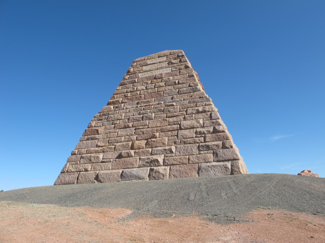
 The next major thing I came upon that rated a picture was the Ames Monument about 20 miles east of Laramie, WY. This truncated stone pyramid
sits on a barren summit and by dint of its size and location is visible for many miles. Before track realignments this was the
highest point on the transcontinental railroad. It was built to honor the Ames brothers, who were instrumental in the
completion of that railroad although it seems that more than a bit of financial and political corruption involving the brothers
(some things never change). Some years later one of the brothers, a US senator, was censured for his behaviour and died soon
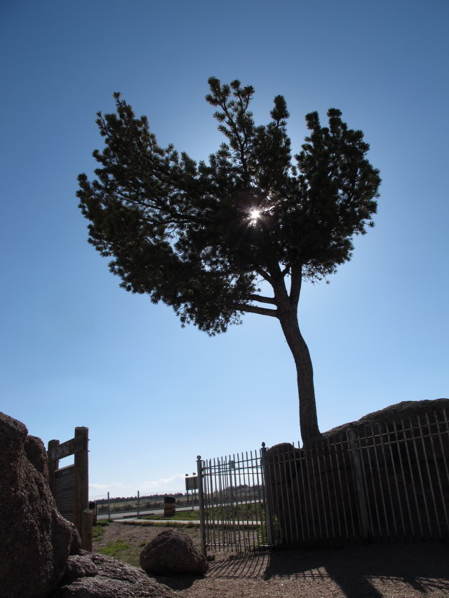
afterward. Not too many miles away, and not many things out here are just a few miles away, is Tree Rock. This pine tree has been a landmark for at least since the days the
railroad first came through. It is said that the workers deliberately put a jog in the track to avoid harming it.
The next major thing I came upon that rated a picture was the Ames Monument about 20 miles east of Laramie, WY. This truncated stone pyramid
sits on a barren summit and by dint of its size and location is visible for many miles. Before track realignments this was the
highest point on the transcontinental railroad. It was built to honor the Ames brothers, who were instrumental in the
completion of that railroad although it seems that more than a bit of financial and political corruption involving the brothers
(some things never change). Some years later one of the brothers, a US senator, was censured for his behaviour and died soon
afterward. Not too many miles away, and not many things out here are just a few miles away, is Tree Rock. This pine tree has been a landmark for at least since the days the
railroad first came through. It is said that the workers deliberately put a jog in the track to avoid harming it.
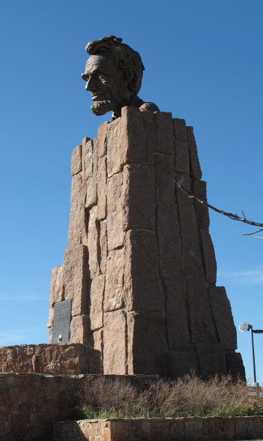 Further up the road, some miles east of Laramie, I came
upon yet another image of Lincoln, seemingly a dime a dozen along the LH route, but this one was exceptional. It is a massive
craggy bronze sculpture of Lincoln's head perched on a 30-foot granite
pedestal. This is not its first incarnation since, when first constructed, sat near the aforementioned Ames monument.
Further up the road, some miles east of Laramie, I came
upon yet another image of Lincoln, seemingly a dime a dozen along the LH route, but this one was exceptional. It is a massive
craggy bronze sculpture of Lincoln's head perched on a 30-foot granite
pedestal. This is not its first incarnation since, when first constructed, sat near the aforementioned Ames monument.
I pressed on for a bit more but cut the day short and found lodgings in Laramie, WY.
Day 6, 15 May 2012
↑ ↓  I awoke in Laramie at 6:00
to reports that the temperature was below freezing. Not what I've come to expect in the middle of May, even after so many years
living in Alaska. After taking care of necessities I headed down the highway toward Utah. To clarify, when I could I stayed on
the old LH except where it disappeared completely and when that happened I was forced to take I-80. Next stop was at Como
Bluff, WY, a rather famous fossil hunting site. There is a sorta-historic cabin there called the Fossil Cabin Museum. From the sign it was closed and for sale at the time and
I don't really know anything about it. This whole area is, to say the least, very very empty. Not to say that this is the
middle of nowhere — that is about three mile back up the road. I snapped a portrait of the Miata along the road as a
keepsake.
I awoke in Laramie at 6:00
to reports that the temperature was below freezing. Not what I've come to expect in the middle of May, even after so many years
living in Alaska. After taking care of necessities I headed down the highway toward Utah. To clarify, when I could I stayed on
the old LH except where it disappeared completely and when that happened I was forced to take I-80. Next stop was at Como
Bluff, WY, a rather famous fossil hunting site. There is a sorta-historic cabin there called the Fossil Cabin Museum. From the sign it was closed and for sale at the time and
I don't really know anything about it. This whole area is, to say the least, very very empty. Not to say that this is the
middle of nowhere — that is about three mile back up the road. I snapped a portrait of the Miata along the road as a
keepsake.

 Down the road after an interval of more empty I came to Medicine Bow.
There isn't a lot there. Probably the best-known landmark is The Virginian Hotel which has been there since 1911. In its day
it was touted as the biggest hotel between Denver and Salt Lake City. Across the road from the hotel is the local museum. If
memory serves they were closed up tight when I was there early in the morning so I just snapped a few exterior pictures. Up the
old highway a bit (some miles to tell the truth but out here everything is pretty far from everything else) I came to the site
of Fort Steele on the North Platte River. This military
outpost was built to protect the construction of the railroad. A few bits of architecture remain but I just snapped a picture
of the river itself.
Down the road after an interval of more empty I came to Medicine Bow.
There isn't a lot there. Probably the best-known landmark is The Virginian Hotel which has been there since 1911. In its day
it was touted as the biggest hotel between Denver and Salt Lake City. Across the road from the hotel is the local museum. If
memory serves they were closed up tight when I was there early in the morning so I just snapped a few exterior pictures. Up the
old highway a bit (some miles to tell the truth but out here everything is pretty far from everything else) I came to the site
of Fort Steele on the North Platte River. This military
outpost was built to protect the construction of the railroad. A few bits of architecture remain but I just snapped a picture
of the river itself.
 I came across this pretty little bit of wetlands and have
been completely unable to determine exactly were it is or what it is called. It is definitely near the Wyoming-Utah border but
that doesn't say too much since that is a vast area.
I came across this pretty little bit of wetlands and have
been completely unable to determine exactly were it is or what it is called. It is definitely near the Wyoming-Utah border but
that doesn't say too much since that is a vast area. After crossing into Utah I took the opportunity at the next exit past their
welcome center to backtrack up the old Echo Canyon Road, an original alignment of
the Lincoln Highway to catch some interesting history and geology.
After crossing into Utah I took the opportunity at the next exit past their
welcome center to backtrack up the old Echo Canyon Road, an original alignment of
the Lincoln Highway to catch some interesting history and geology.
After a suitable period of reflection I headed down the highway to the first place that seemed likely to have a motel or hotel.
This happened to be Coalville, UT.
Day 7, 16 May 2012
↑ ↓
 I awoke early in Coalville, Utah, my body still running two time zones
askew. I had missed something up the road yesterday so I decided to backtrack up north of Echo Canyon to see Devil's Slide.
This geologic feature has been a stopping point since the earliest days and the government has conveniently created an extra
lane for parking along the highway to accommodate gawkers (I had just put in the word sightseers there and it looked like
some sort of supernatural talent). Devil's
Slide shows that some serious upheaval has taken place here; I've seen similar folded and flopped rock layers before but
none seem quite as obvious as this. The other shot is of the old train tracks where they were driven through a stubborn rock
outcrop west of Devil's Slide. That detour complete I turned around and headed back toward Coalville to continue down the LH.
Unfortunately fate had it in for me and after a lot of fumbling I couldn't find my way back to the proper road so I headed west
on I-80.
I awoke early in Coalville, Utah, my body still running two time zones
askew. I had missed something up the road yesterday so I decided to backtrack up north of Echo Canyon to see Devil's Slide.
This geologic feature has been a stopping point since the earliest days and the government has conveniently created an extra
lane for parking along the highway to accommodate gawkers (I had just put in the word sightseers there and it looked like
some sort of supernatural talent). Devil's
Slide shows that some serious upheaval has taken place here; I've seen similar folded and flopped rock layers before but
none seem quite as obvious as this. The other shot is of the old train tracks where they were driven through a stubborn rock
outcrop west of Devil's Slide. That detour complete I turned around and headed back toward Coalville to continue down the LH.
Unfortunately fate had it in for me and after a lot of fumbling I couldn't find my way back to the proper road so I headed west
on I-80.
There are no other entries in the notes for a while until I note: Eventually got to Park City, ne plus ultra yuppie
enclave. Don't think my kind welcome here. Found Starbucks and hadda' mocha.
I didn't snap even one picture here.
Further on, the highway skirts the southern edge of the Great Salt Lake. I really only stopped for a bit there at a place
called The Great Saltair which was, in old times a popular day trip destination for many LDS members from Salt Lake City. The
present structure is the third iteration, the previous two having suffered various disasters. Right now it is still a tourist
stop but is more known as a music venue. I found the most fascinating thing about the place was the vast swarms of swallows
nesting up under the eaves of the towers. Oh, and there were some bikers there and one of them had the most gorgeously-painted
ride I've ever seen. The Saltair sits on a little peninsula giving a perfect view of the expanse of the lake.
 Further down
the highway a bit and in a superbly desolate area I came upon the a memorial at Schellbourne Station which commemorates the Pony
Express which rode through here for perhaps four years before the telegraph rendered them obsolete. That anybody would ride
through here alone and in all sorts of weather is simply amazing.
Further down
the highway a bit and in a superbly desolate area I came upon the a memorial at Schellbourne Station which commemorates the Pony
Express which rode through here for perhaps four years before the telegraph rendered them obsolete. That anybody would ride
through here alone and in all sorts of weather is simply amazing.
 Down the highway
Utah morphed into Nevada at West Wendover. Without markers it would still be easy to tell when you cross the state line. On the
east it is pretty plain but instantly there are flashy casinos on either side of the highway. Soon after, I got to the town of
McGill, Nevada. I can't really describe it as a ghost town because people still live there but it is really bad off. It was
quite prosperous up until 1983 when the Kennecot corporation closed the copper smelter and the town's population dropped
precipitously. I noted with surprise that there was still a Greek Orthodox church in the town which suggests a population from
unexpected sources in the old days. One odd tourist destination in McGill is the old drug store which is now a public museum but with a real difference: it has no
displays as such — it was simply frozen in time on the day it closed in 1979 and all of the displays and products are now
as they were then.
Down the highway
Utah morphed into Nevada at West Wendover. Without markers it would still be easy to tell when you cross the state line. On the
east it is pretty plain but instantly there are flashy casinos on either side of the highway. Soon after, I got to the town of
McGill, Nevada. I can't really describe it as a ghost town because people still live there but it is really bad off. It was
quite prosperous up until 1983 when the Kennecot corporation closed the copper smelter and the town's population dropped
precipitously. I noted with surprise that there was still a Greek Orthodox church in the town which suggests a population from
unexpected sources in the old days. One odd tourist destination in McGill is the old drug store which is now a public museum but with a real difference: it has no
displays as such — it was simply frozen in time on the day it closed in 1979 and all of the displays and products are now
as they were then.


 The day ended up in Ely,
Nevada, a town which I hadn't been in for decades when I lived in California and then Nevada. It is seriously out of the way
from almost everywhere. The place had been seriously hit by the recession and seemed to still be trying to find its way out.
The number of empty properties was obvious from the number of real estate signs. The most prominent landmark is still the Hotel
Nevada and Gambling Hall. This is not a flashy place and in some regards you might be forgiven if you had 1970s deja vu if you
didn't look at the tiny details. I snapped a few other pictures in town: I'm a sucker for old advertising signs so I will share
a couple of those too. I had an indifferent supper at a little generic Asian restaurant but my notebook says that I won $9.50
on a poker machine in a local bar where I stopped for a beer so not all was lost.
The day ended up in Ely,
Nevada, a town which I hadn't been in for decades when I lived in California and then Nevada. It is seriously out of the way
from almost everywhere. The place had been seriously hit by the recession and seemed to still be trying to find its way out.
The number of empty properties was obvious from the number of real estate signs. The most prominent landmark is still the Hotel
Nevada and Gambling Hall. This is not a flashy place and in some regards you might be forgiven if you had 1970s deja vu if you
didn't look at the tiny details. I snapped a few other pictures in town: I'm a sucker for old advertising signs so I will share
a couple of those too. I had an indifferent supper at a little generic Asian restaurant but my notebook says that I won $9.50
on a poker machine in a local bar where I stopped for a beer so not all was lost.
Tomorrow I hit The Loneliest Road in America heading west.
Day 8, 17 May 2012, On the Loneliest Road
↑ ↓  Arose
very early in Ely, NV and hit the road at 6:50. The notes for this day are sparse. Very sparse. So I'll just wing it with a few
pictures. I had driven this road at least once before but I can't remember if it was when I was stationed in Silicon Valley or
when I was stationed in Las Vegas. It was a lot more lonely back then — eerily so since I remember it was on a moonlit
night with the eyes of various animals reflecting in the headlights. The state tourism folks pushed pretty hard to popularize
the route a while back and perhaps that has made the road a bit less lonely.
Arose
very early in Ely, NV and hit the road at 6:50. The notes for this day are sparse. Very sparse. So I'll just wing it with a few
pictures. I had driven this road at least once before but I can't remember if it was when I was stationed in Silicon Valley or
when I was stationed in Las Vegas. It was a lot more lonely back then — eerily so since I remember it was on a moonlit
night with the eyes of various animals reflecting in the headlights. The state tourism folks pushed pretty hard to popularize
the route a while back and perhaps that has made the road a bit less lonely.
About here I should, if keeping to form, post a picture taken from the driver's seat of the empty road ahead but I'll save that
and offer you something far better at the end.


 The first town along the way was Eureka and, at an early hour of the morning, there
was nothing going on although I suspect that this is probably true all the time unless a tour bus comes through. There are
really only two buildings in town that most people would pay attention to: the opera house and the courthouse. Both of these date from the mining boom days.
The opera house has been just that and then a movie theater and then abandoned and then restored as a live venue. The stage and
fire screen has been restored to something like a historical state. The dressing rooms for the acts is down a steep stairway
and it seems that everybody who has played there has also left their marks on the walls.
The first town along the way was Eureka and, at an early hour of the morning, there
was nothing going on although I suspect that this is probably true all the time unless a tour bus comes through. There are
really only two buildings in town that most people would pay attention to: the opera house and the courthouse. Both of these date from the mining boom days.
The opera house has been just that and then a movie theater and then abandoned and then restored as a live venue. The stage and
fire screen has been restored to something like a historical state. The dressing rooms for the acts is down a steep stairway
and it seems that everybody who has played there has also left their marks on the walls.


 Many miles further on I
came to the Hickison Petroglyphs Recreation Area. Sadly there are no great pictures here to share. Almost every one I snapped
was either no good or had my Woodcentral website cap prominently displayed into which I intended to post on their
sightings page where readers share their pictures of their travels. A bit further yet and up a dirt road near Austin,
NV I came to the remains of Stokes Castle. The history of this folly
seems to be a perfect illustration of what happens when people are unprepared for great wealth suddenly acquired. At the best
of times this was never a good place to live. Little things like lack of water and inaccessibility pretty well guaranteed that.
Then came a view of Sand Mountain. This is a recreational site once known for singing sands but which is now overrun by
off-road vehicles of all sorts and which is reputed to be thoroughly obnoxious. There is no hearing the sand sing over the roar
of an engine. In any case I didn't divert from the main highway to get any closer, being satisfied with a sudden bit of good
lighting which cropped up for me.
Many miles further on I
came to the Hickison Petroglyphs Recreation Area. Sadly there are no great pictures here to share. Almost every one I snapped
was either no good or had my Woodcentral website cap prominently displayed into which I intended to post on their
sightings page where readers share their pictures of their travels. A bit further yet and up a dirt road near Austin,
NV I came to the remains of Stokes Castle. The history of this folly
seems to be a perfect illustration of what happens when people are unprepared for great wealth suddenly acquired. At the best
of times this was never a good place to live. Little things like lack of water and inaccessibility pretty well guaranteed that.
Then came a view of Sand Mountain. This is a recreational site once known for singing sands but which is now overrun by
off-road vehicles of all sorts and which is reputed to be thoroughly obnoxious. There is no hearing the sand sing over the roar
of an engine. In any case I didn't divert from the main highway to get any closer, being satisfied with a sudden bit of good
lighting which cropped up for me.

 Next place up the road was Virginia
City, another famous old mining town now living life as a tourist destination. I'll give them credit though, they do it
pretty well. There are a goodly number of picturesque buildings and interesting shops. I was taken by one building in
particular: Fourth Ward School. One detail if the building struck me and, with the clear mountain air and a favorable light
direction, the effects of a polarizing filter are profound. I've been accused of over-using this trick but when it works, it
works.
Next place up the road was Virginia
City, another famous old mining town now living life as a tourist destination. I'll give them credit though, they do it
pretty well. There are a goodly number of picturesque buildings and interesting shops. I was taken by one building in
particular: Fourth Ward School. One detail if the building struck me and, with the clear mountain air and a favorable light
direction, the effects of a polarizing filter are profound. I've been accused of over-using this trick but when it works, it
works.
I left Virginia City with intentions of finding a stopping place down around the California border since it wasn't too far ahead now. Unfortunately, my notes say that there were massive delays caused by construction. Whatever happened, all planning (such as it was) fell apart and I kept on driving too long. I do remember stopping at one place advertising vacancies along the way and asking for a room was quoted a price that would have motivated me to sleep on the ground cuddled up with a rattlesnake instead. As it was I got all the way to Roseville, CA before stopping, dead tired, for the night at 8:30.
Day 9, 18 May 2012, End of the Highway in San Francisco
↑ ↓ 
 The map says that it is less than 100 miles to the western terminus of
the Lincoln Highway in Lincoln Park in San Francisco so there was no great need to hurry. My notebook says
The map says that it is less than 100 miles to the western terminus of
the Lincoln Highway in Lincoln Park in San Francisco so there was no great need to hurry. My notebook says Doing laundry
this AM since I got in so late and drove so far last night.
Exciting stuff, that. I got the laundry done and got
moving at 9:00. Intending to visit some wineries, or one winery in particular, I headed south toward Galt and then Lodi and the
Michael David Winery to see where some of my favorite wines originated. I can say
that it is a beautiful setup and I wish I could have stayed longer but as it was I spent a serious fortune there, nearly $150,
including an oversized bottle of their Gluttony for some wine-fancier friends in Knoxville. The only saving grace
might have been that the tiny trunk on the Miata would prevent me from going seriously crazy and I wasn't about to stow wine in
the passenger seat. I also came across the Vermeil and V. Sattui Wineries. I don't
remember what I bought at the former but at the latter I bought some excellent rosé which I've ordered from them since,
it being only available directly at the winery. I stopped later at an In-n-Out in Lodi and got a reminder of why they are so
popular among the burger snobs. I do remember that it was a great burger and that I sat at a picnic table outside while eating
it and studying a map. Further down the road I bought a bag of fresh cherries at an orchard's roadside stand. That is one of my
favorite road treats and I finished them off pretty quickly and distributed the seeds roadside as I drove.
I went straight for San Francisco and, as much as I hate driving through big cities, got to the vicinity of the terminus. About then things started to fall apart. I didn't know exactly where the end was and nobody I asked knew either and I did ask at least ten people within five miles. I stopped at a golf course (yes, there is actually a golf course in the city and there is no telling what sort of gigabucks that much land much might be worth) and asked them and despite my destination being not more than a mile away nobody claimed to know where it was. Eventually, and I don't remember exactly how, I did find my way to Lincoln Park up the hill and snapped a picture of that last marker. The park is quite lovely and was quite unexpected despite my having lived down the peninsula and having visited the city a number of times. The park includes the California Palace of the Legion of Honor and San Francisco Holocaust Memorial. I was grateful that there were no great crowds to contend with, those being one of the things that bothers me so intensely about big cities.


Somewhere about this time I came to a decision that would irretrievably change (or maybe break) my trip. The plans were always fluid but in the back of my mind was the intention to make it to the end of the Lincoln Highway and to then head up the coast, or maybe up I-5, to Washington to visit some friends. Somewhere in the last couple of days another idea came to mind that I should attend an event, the Bay Area Maker Faire, which was being held down the peninsula in San Mateo. I'm willing to swear that this wasn't my original intention but by some coincidence (or was it?) I wound up just miles away on the day before it was to begin. My thought processes being what they were I flipped my mental toggle switch and decided to go, justifying the decision by reasoning what difference would a couple of days make when there was no schedule to begin with. I was lucky enough to find a room fairly close to the event location at the Los Prados Hotel, then a Best Western property, although the price was insanely high, likely because of event pricing or maybe weekends are always that high. I was fortunate in that there were an abundance of reasonably-priced restaurants within walking distance so I settled in for the duration.
Day 10-11, 19-20 May 2012, At Maker Faire then Away
↑ ↓ How to describe Maker Faire? The best I can do is crib from the Maker Media website, the
creator and organizer: Part science fair, part county fair, and part something entirely new, Maker Faire is an all-ages
gathering of tech enthusiasts, crafters, educators, tinkerers, hobbyists, engineers, science clubs, authors, artists, students,
and commercial exhibitors. All of these “makers” come to Maker Faire to show what they have made and to share what
they have learned.
That goes part of the way. I'd have to add that there is a big contingent of geeks and nerds and freaks
and borderline anarchists mixed in. I am certainly a nerd and a maker but was totally unprepared for a lot of what was going
on. But it was fun!
I arrived at the San Mateo County Event Center pretty early and was still far back in a very long queue. At least the weather was pleasant and not too hot so a half hour went by painlessly. After the queue it was something akin to escape and everybody's mood seemed to lighten as people spread out. Some knew where they were going but most, like me, were just wandering bemused among the sometimes-strange displays. Want to have your kids learn to pick locks? They've got a place for that. Want to do science fiction cosplay? They've got a place for that. Robots? Yes, certainly. 3-D printers? Everywhere. Light displays? Blindingly obvious. Giant fire-breathing metal dragons? Of course. In fact, anything having to do with flames was in — I must have seen at least a half dozen objects of various sorts blasting away. I'm afraid I may be copping out here because the only way I can think to illustrate the Faire is with some videos. They are all pretty small and none will auto-play. The first one over there is probably my favorite. Basically it is two huge Tesla Coils rigged so that they can, at will, be modulated by music. The show presenters did a bunch of other stuff too but the music impressed me most. I tried, as a kid, to build a (much smaller) coil of my own but I must have gotten something wrong because I never got more than an inch or two of spark out of it.
I came about this close to buying the plans and parts kit for the little blue robot but was saved by the fact that the inventor/vendor hadn't worked out the manufacturing process yet. I guess that saved me a few hundred right there. Oh, and the last video might require some explanation: this was about the time that everybody in the world seemed to be awed by what happens when Mentos candy and Coca-Cola get together in the bottle. The two guys on stage were featured in a lot of online videos and, to the nerdy attendees, had rock-star status.
Notes say that I left San Mateo around noon and headed up California Route 29 with intentions of making it to Washington in record time to do my visiting. I got as far as Clearlake before fatigue set in and forced me into a motel. Notes say that the place had no working Wi-Fi but I didn't really record anything else. I do remember walking down to the park by the lake and making some phone calls and, given my appetite, I must have found someplace to eat. That's it for the night...
Day 12, 21 May 2012, Things May Be Falling Apart
↑ ↓ It definitely looks as though things weren't going well. My first note entry was a whinge about the motel in Clearlake being noisy, having a bad restaurant, and offering no "free" breakfast (as if there really could be such a thing). At 7:00 things were not all bright and shiny. Clearly I was driving quite fast and probably not paying attention to the sights along the way. I do vaguely remember driving through a bit of redwood forest up near the Oregon border. And somewhere after crossing it I stopped at a roadside apiary and bought some blackberry honey which proved to be excellent but I can't even say what highway it was on. Most likely it was route 199 but I can't say for sure despite going all CSI to figure it out.
A cryptic note entered some 370 miles after my start for the day says Cloudy at Shasta and threatening rain so Skipped
Crater Lake. Oregon Caves at 3:50 but that is too late for tour.
If anybody can figure out why I'd be mentioning those
sights if I really was on the highway I thought I was, please let me know. As another irritant I noted being held up for close
to an hour by road construction and a stretch of one-way traffic. Eventually, and I must have been in a right state by then, I
found myself in Brookings, Oregon for the night.

Day 13, 22 May 2012, Giving Up
↑ ↓ The first note for this day simply says 22
May Brookings Giving up 49743 (miles) ~7:14 Long way to go grey drizzle
What prompted the actual surrender is not
noted. Perhaps it was a collision of bad mood and grey sky. Perhaps I had taken a good look at my spending so far. Perhaps I was just
getting old. In any case I decided to high-tail it toward home. For some reason I decided that going down the
largely-featureless I-5 south and picking up the nearly as featureless I-40 east would be fastest. Looking back I probably
should have taken I-70 where I might have seen some scenery in the mountains. But my mind was made up and that was that.
 That evening and about 500 miles
later I stopped at Patterson, CA, a place I had never heard of before. There are many equally unknown places up and down the
Central Valley which I largely ignored when I lived in the Bay Area and Nevada. I noted that Patterson is on the California
Aqueduct, which I had heard of, and that it billed itself as "Apricot Capital of the World" which I cannot
corroborate.
That evening and about 500 miles
later I stopped at Patterson, CA, a place I had never heard of before. There are many equally unknown places up and down the
Central Valley which I largely ignored when I lived in the Bay Area and Nevada. I noted that Patterson is on the California
Aqueduct, which I had heard of, and that it billed itself as "Apricot Capital of the World" which I cannot
corroborate.
The pictures today add to the confusion about what route I actually took. There are a few coastal pictures taken hours after my
departure time which suggest that I didn't actually head straight to I-5. Did I actually head down 101 first? Damned if I know
and no way to prove it either way. In any case here are two coastal pictures and one way down south along the California Aqueduct.

Days 14-17, 23-26 May 2012, And Then Run All the Way Home
↑ ↓ Ok. I was in full flight mode and determined to make my way east in the minimum time possible. This clearly meant that I wasn't looking out for interesting places to stop and side trips to take. I did take a few pictures and stopped at a few places not directly involved in fueling the car, fueling my stomach, or sleeping. I've made cross-country trips like this a number of times in the past and they all seem to be melt together into a single mass except for the times when weather, breakdown, or illness create their own memories. I had none of these during my headlong flight. First night of flight was spent in Kingman, AZ.

 New Mexico: The first pictures of note were in New Mexico. First
one appears to be the Painted Desert Indian Center in/around Holbrook. I believe that I stopped there out of a combination of
curiosity and hunger. This stretch is on what was once old Route 66 and appears to have been here for a long time. The second
picture is a bit better: the San Jose de la Laguna Mission
Church at the Laguna Pueblo. I stumbled onto this and wound up being a bit embarrassed. I got off the highway because I was
drawn by the apparent historical building and stumbled into some sort of important ceremony that was being held. In theory
there were supposed to be signs and watchers at the entry to the pueblo keeping strangers out but I saw none of them if they
were even there. After profuse apologies I made to leave but two members of the tribe offered to show me the old church
although no photos of the lovely interior were permitted. Out of guilt I dropped some cash in the offering box, snapped a few
pictures of the outside (being careful to stay clear of the ceremonies happening down the hill in back) and left quickly.
Second night of flight was spent in Tucumcari, NM.
New Mexico: The first pictures of note were in New Mexico. First
one appears to be the Painted Desert Indian Center in/around Holbrook. I believe that I stopped there out of a combination of
curiosity and hunger. This stretch is on what was once old Route 66 and appears to have been here for a long time. The second
picture is a bit better: the San Jose de la Laguna Mission
Church at the Laguna Pueblo. I stumbled onto this and wound up being a bit embarrassed. I got off the highway because I was
drawn by the apparent historical building and stumbled into some sort of important ceremony that was being held. In theory
there were supposed to be signs and watchers at the entry to the pueblo keeping strangers out but I saw none of them if they
were even there. After profuse apologies I made to leave but two members of the tribe offered to show me the old church
although no photos of the lovely interior were permitted. Out of guilt I dropped some cash in the offering box, snapped a few
pictures of the outside (being careful to stay clear of the ceremonies happening down the hill in back) and left quickly.
Second night of flight was spent in Tucumcari, NM.

 Texas: Just a couple of snapshots in passing. First is an art deco relic of the old Route 66
days. This is the Tower Staion and U-Drop Inn Cafè in Shamrock,
Texas which dates from the mid-1930s. It is a reminder of the sometimes grandiose buildings that sometimes show up in otherwise
forgettable places. For reference, look at some of the county seat buildings I showed earlier. The second picture was taken at
a rest stop along the interstate and is just a reminder of life in the west: tourists need to be warned about the most obvious
things. Earlier I had seen a similar sign but warning of not only the snakes but scorpions. I guess today we'd have to post
signs about ticks too. By the third night of flight I stayed in Russelville, AR.
Texas: Just a couple of snapshots in passing. First is an art deco relic of the old Route 66
days. This is the Tower Staion and U-Drop Inn Cafè in Shamrock,
Texas which dates from the mid-1930s. It is a reminder of the sometimes grandiose buildings that sometimes show up in otherwise
forgettable places. For reference, look at some of the county seat buildings I showed earlier. The second picture was taken at
a rest stop along the interstate and is just a reminder of life in the west: tourists need to be warned about the most obvious
things. Earlier I had seen a similar sign but warning of not only the snakes but scorpions. I guess today we'd have to post
signs about ticks too. By the third night of flight I stayed in Russelville, AR.

 I finally made it back to Tennessee but still a long way from home when I
crossed the big bridge across the Mississippi to Memphis. Pictures were as sparse as they had been for the past few days. The
first is the actual bridge. The second is a big statue of BB King in the welcome center at Mud Island River Park. I got home and finally wrote "fin" as the last
entry of the log book at 6:15. As best I can figure the total drive covered about 6,700 miles. The total cost is something I'd
still rather not know even six years later.
I finally made it back to Tennessee but still a long way from home when I
crossed the big bridge across the Mississippi to Memphis. Pictures were as sparse as they had been for the past few days. The
first is the actual bridge. The second is a big statue of BB King in the welcome center at Mud Island River Park. I got home and finally wrote "fin" as the last
entry of the log book at 6:15. As best I can figure the total drive covered about 6,700 miles. The total cost is something I'd
still rather not know even six years later.
So, would I do such a thing again? Yeah, probably. But next time it will have to be a matter of absolutely no planning or definite goal. I've pretty well concluded that the reason I gave up was a feeling of pressure to get to Washington in a timely manner along with the quickly ballooning expenses. Had I skipped the Maker Faire I'm certain I would have made it to Washington just fine and never looked at the bills until afterward. Let that be a lesson: ignore the things you don't want to know lest they hold you back from doing the things you want to do.
 ©Google Maps")
This website does not use cookies or javascript and collects no user information.